Dreaming your city: Brest and Dresden

This exhibition, on show in Brest in summer 2023, presents the work of students from the Collège de Penn ar C’hleuz in Brest and the Evangelisches Kreuzgymnasium in Dresden on the theme of the city of their dreams. With their paintings, drawings, collages and digital illustrations, these young artists invite us to explore their unique vision of architecture, town planning and the urban environment. Their creations reflect their dreams and aspirations, but also their understanding of the social and environmental issues shaping our modern cities.

Exhibition in Brest
Exhibition in Brest
Exhibition in Brest
Exhibition in Brest

Plan of Brest according to Vauban’s project, late 17th century, Brest Municipal Archives.

Sébastien Le Prestre de Vauban (1633-1707) was probably the most famous designer of fortifications of his time, if not of all time. His fame was on an international scale. Both an engineer and military architect, he gave France the “iron belt” – a defensive system of ramparts that remained functional until the early 19th century and beyond.

He was appointed ‘commander of the place of Brest’ and stayed for some time in the city, whilst remaining critical of its geomorphology which he found unsatisfactory. This plan, drawn up by an anonymous hand, shows the difficulty of adapting Vauban’s ideas to the organisation of the streets, which he would have liked to set out in a more regular pattern. We see this principle applied not only to the left bank of the Penfeld (“Brest-même”), but also to the right bank (Recouvrance). These two areas are united within a protective enclosure which would later pose real problems when the town needed to expand.

Beyond the city walls, the green countryside with its fields and paths, already presages the arrival of the streets that would be laid out on the outskirts of the historic town in the 19th century.

Sonia de Puineuf

Louis-Nicolas Van Blarenberghe, View of the Port of Brest, 1774, oil on canvas, Musée des Beaux-Arts de Brest.

Louis-Nicolas Van Blarenberghe (1716 – 1794), who descends from a family line of painters from French Flanders (Lille), is best known for his battle scenes and his depictions of ports. He painted several views of the port of Brest as it was strategic for the defence of France.

This large painting is one of those 18th century paintings that alludes to the city of Brest rather than showing it clearly. Artists were always more inspired by the activity taking place in the arsenal than that in the streets. In this painting, we are situated at the mouth of the Penfeld, a river that provides exceptional natural shelter for fleets. Shipbuilding work is being carried out by the convicts in the foreground. Behind them, on the right, we can make out the silhouette of Brest castle, and on the left, the Navy buildings’ string of orderly facades.

The painter pays particular attention to the light by painting a vast sky with golden hues. The liveliness of the Penfeld is thus glorified: the port of Brest was the pride of both the city and the kingdom at the time. Maritime activity is at the heart of Brest’s imagination.

Sonia de Puineuf

Bernardo Bellotto, known as Canaletto or Canaletto the Younger, Dresden, view of the right bank of the Elbe below the Augustus Bridge, 1747, Gemäldegalerie Alte Meister Dresden.

The Italian artist Bernardo Bellotto (1721/22 – 1780), nephew of the famous Venetian painter Canaletto, painted this large canvas during his stay in Dresden. It is one of the most famous 18th century views of the city of Dresden at a time when it attracted the attention of artists from all over Europe thanks to its architectural splendour.

The artist painted some of Dresden’s most beautiful monuments on a slightly oversized scale (The Augustus Bridge, the Frauenkirche and the Holy Trinity Church). Their silhouettes stand out against a large blue sky whilst being reflected at the same time in the river Elbe below. It is a grandiose depiction in the tradition of vedute (topographical views containing architectural elements) – a popular genre of painting at the time. With his meticulous touch, Bellotto endeavoured to depict with precision the elegant architecture of the city and its river activity. Thanks to his refined colour palette, he creates a bright and soothing atmosphere.

This painting is part of a large series of paintings that show Bellotto’s fascination with the Saxon capital. These dreamy images fed the imagination of Dresden throughout its history, even serving as a reference for those involved in the reconstruction of the city’s historic centre at the end of the 20th century.

Sonia de Puineuf

Claude Jean-Baptiste Jallier de Savault, Unrealized project for the Place Louis XVI, plan, ca. 1785, Musée des Beaux-Arts de Brest.

This drawing presents an urban embellishment project imagined by the architect Claude Jean-Baptiste Jallier de Savault (1739-1806) at the end of the Enlightenment period. The spectacular project he proposed to carry out included installing the royal statue, donated by the ‘Etats de Bretagne’ (The Estates of Brittany) in 1784, at the tip of the castle’s peninsula.

One glance at the title of this plan is all it takes to grasp the symbolic and practical problems that its development would cause. First of all, its purpose was tohonour the king as liberator of the seas, crowned with glory at the end of the American War of Independence: the statue would therefore “hold dominion over the port, the roadstead and the Goulet”. In the spirit of the time, this type of monument was seen as a true incarnation of the monarch and it is easy to understand why placing his statue at the heart of the kingdom’s largest arsenal would indeed help to glorify his image as the heroic supreme commander of the Navy.

There were also the practical challenges of making this royal square coexist with the “establishments planned by the Navy”. Warehouses, which were to be built below and in front of the castle would intermingle with this monumental project in a skillful interweaving between public and military spaces. However,,the risks incurred by this rather original form of cohabitation finally prompted the Naval administration’s decision to abandon the project, which was strongly disapproved of by the population, even before the Revolution broke out.

Yvon Plouzennec

François de Cuvilliés the Elder, Project for the demolition of the fortifications of Dresden, 1761, SLUB Dresden Deutsche Fotothek.

King Frederick II of Prussia’s bombardment of Dresden during the Seven Years’ War was the worst destruction the city suffered before the bombings of 1945. Following the destruction of its suburbs in November 1758 and August 1759, the walled city itself came under attack for the first time from 19th to 22nd July 1760. After this attack, the south-eastern part of the fortress – roughly one third of its buildings – lay completely in ruins.

To avoid further damage, King Augustus III ordered the rapid demolition of the fortress, despite strong resistance from the military: the walls were dismantled and the moat filled in. Initial plans, drawn up by the architect Julius Heinrich Schwarze (1706-1775) ran into
difficulties due to property rights, as the numerous private plots of land on the Counterscarp (the outer side of the fortress) prevented the creation of a symbolic promenade with squares opening out onto streets to create perspective.

It was probably the princely elector couple Friedrich Christian (1720-1763) and Maria Antonia (1724-1780) who, whilst taking refuge in Munich from January 1760 to January 1762, established contact with François de Cuvilliés (1695-1768), the Bavarian court architect.
The plan he designed was the most majestic in 18th century Dresden. Its main feature was the construction of a 45-metre-wide avenue across the fortress moat, intercepted by circular and square spaces marking the entrances to the walled city. Another important element of the project was the construction of a huge palace (residential castle) on the fortress grounds northwest of the Zwinger. Its elongated forecourt and grandiose garden facing towards the Ostragehege, would have created a vast complex, making the historic town appear as little more than an ancient appendage.

In the end, Cuvilliés’s project was quickly abandoned. When Dresden was destroyed in the early 19th century, more modest plans were adopted which took the significance of the property much more into account.

Stefan Hertzig

Bernardo Bellotto, known as Canaletto or Canaletto the Younger, View of the destroyed Kreuzkirche, copperplate engraving, 1765, SLUB Dresden Deutsche Fotothek.

City views of Dresden became well known thanks to the circulation of engravings – multiple images that could be purchased at low cost. Some of Bellotto’s paintings were reproduced as prints. This one shows how the construction of “Florence on the Elbe” (as Dresden was once called) was only made possible through accidental or sometimes planned destruction, which was often used to the builders’ advantage.

Here, the artist depicts the ruins of the Kreuzkirche (Church of the Holy Cross) after the collapse of its tower. This historic church was badly damaged during the Seven Years’ War and was being rebuilt in a different, more modern style when its tower suddenly collapsed in spectacular fashion.

Located at a key point in the city (on the Altmarkt), this church, whose origins date back to the Middle Ages, has inevitably undergone several destructions and reconstructions over the centuries.

Sonia de Puineuf

Gussy Hippold-Ahnert, Bathhouse at the Blue Miracle, 1935, Hygiene-Museum Dresden.

This small watercolour from the 1930s by Gussy Erika Hippold-Ahnert (1910-2003) depicts the Loschwitz Bridge, which was opened in 1893 and was nicknamed the “Blue Miracle”. Its metal construction without piles in the river was considered a great technical achievement and as such was much admired. The bridge soon became a dominant feature of Dresden, a city on the road to modernity.

At the foot of the bridge, the artist shows a bathhouse that was accessed by a small footbridge. Dresden was known for the emphasis it placed on public health. The Loschwitz Bridge connected the city to the district where, at the turn of the century, numerous sanatoria were built. Many great names from the world of art and politics stayed there, helping to forge a new image of Dresden as the capital of healthy living.

Sonia de Puineuf

Hans Scharoun, Design submitted for the German Hygiene Museum competition in 1920, with the Zwinger in the background, Archiv der Akademie der Künste Berlin.

Hans Scharoun (1893-1972), one of the great German architects of the 20th century, took part in the competition for the German Hygiene Museum in Dresden in his youth. This expressionist watercolour shows a building with an extensive plan including a striking crystalline form, in the perspective of the Zwinger buildings. In the background, the silhouettes of the towers and domes of the historic city can be seen.

As early as the Belle Epoque, the creation of a Hygiene Museum was being envisaged in Dresden. The project was initiated by Karl August Lingner, an industrial chemist who developed the famous Odol mouthwash. His commercial success enabled him to organise international hygiene exhibitions in Dresden, which attracted large audiences.

Due to the vicissitudes of history, the museum was not built until 1930. The huge building was not erected on the site that Hans Scharoun had originally assigned to it in his image, but on the other side of the historic city centre, opposite the Großer Garten.  Its sheer size and power help us understand why Wilhelm Kreis, its architect, was one of Hitler’s favourite architects after 1933.

Sonia de Puineuf

Walter Hahn, Dresden-Striesen, Germany. View of the district with Waldersee-Platz (Stresemannplatz). Oblique aerial view from the east, 1924, SLUB Dresden Deutsche Fotothek.

Walter Hahn (1898-1969) took aerial photographs of the district of Striesen. This area developed, at the end of the 19th century in the east of the city, into a leafy residential suburb. A flourishing horticultural industry led to the growth of this historic village, which in turn contributed to the economic development of Dresden.

From 1860 onwards, Striesen expanded according to a town planning scheme which organised parcels of land into a grid pattern. Elegant villas and apartment buildings surrounded by gardens met the needs of the hygiene movement.

Striesen underwent a major industrial boom at the beginning of the 20th century thanks to, for example, camera and cigarette production, but this did not destroy its green and leafy character. This photograph from 1924 shows the picturesque buildings regularly arranged amongst the greenery: a pleasant living environment for its inhabitants, based on the concept of the garden city.

Sonia de Puineuf

Map of the Saint-Martin district: Annexation plan (1877), from Moulin à poudre road to Valy-Glas, Kerfautras Street, Rue de Paris (Paris Street) and the Place de la Liberté (Freedom square), 1877, Brest Municipal Archives.

The Saint-Martin district (first known as the Annexion district) resulted from the municipality’s desire to create a suburb containing all the necessary living facilities. This urban planning operation came about in response to an increase in population that the city centre could no longer accommodate.

The land acquired by the town of Brest was taken from the neighbouring commune (Lambézellec) – hence the name ‘Annexion’. The land that was once made up of fields with a few farms was transformed into a characteristic ‘end of the 19th century’ style neighbourhood.

This development plan shows the buildings organised in a regular grid of streets branching out from the church dedicated to Saint Martin. The covered market (behind the church), a school and a public washhouse were built here. These buildings embodied the drive for economic and social progress that animated the Third Republic: trade, education and hygiene.

The district suffered little damage during the war and still boasts buildings which date from that period. In addition, more recent development projects have been carried out on land formerly belonging to religious congregations.

Sonia de Puineuf

Joseph-Victor Tritschler, Unrealized project of the bridge in Brest (Penfeld), 1843, Brest municipal archives.

As the historical cradle of Brest, the Penfeld River is intimately linked to the city’s destiny. The merchant and military ports developed along its banks. However, for a long time the only means of crossing between the two banks was by ferry and its crossings were as irregular as they were dangerous.

It was only in 1861, under the Second Empire, that the Imperial Bridge was finally inaugurated after nearly 30 years of procrastination and controversy between local and national authorities. Several spontaneous proposals had preceded it, including that of Joseph-Victor Tritschler (1815-1879).

In 1843, this entrepreneur and town councillor, who was not without artistic talent, proposed a project for a suspension bridge with a large arch. The bridge would have had a movable deck and would have opened in the middle to allow the naval vessels with the highest masts to pass. Its monumental arch would have risen 55 metres above the highest tides and its 400 steps would have allowed pedestrians to continue crossing despite the passage of ships.

Although retained by the municipal council of the city of Brest in 1852, Tritschler’s spectacular project was finally discarded in favour of the swing bridge presented by Nicolas Cadiat and Alphonse Oudry, respectively architect and engineer.

Christine Berthou-Ballot

Brest, oceanic port, plan marketed in 1919, coll. part.

The development of maritime trade between America and the Old Continent benefitted a number of Atlantic coastal cities. Le Havre, for example, became the main port for ships sailing from France to New York. Brest also dreamed of becoming a major transatlantic port able to welcome thousands of passengers heading to and from the United States.

Between 1883 and 1919, considerable efforts were made by the Chamber of Commerce to persuade the French government to allow Brest the privilege of operating a commercial line that would have enabled it to rival Panama and Colon in terms of maritime traffic. This would have given the city the opportunity to broaden its maritime industry, which was at that time centred around the Navy. This project aimed to improve the town’s road and rail networks, and finally allow it to expand its maritime domain.

It was in this context that the plan for Brest, the oceanic port, was born.  One can conclude that this plan would have involved a major extension of the city towards the sea with facilities dedicated specifically to transatlantic traffic. Although this project never came to fruition, it was nevertheless presented in various tourist documents as a given. This attempt to force the hand of destiny was a dream that seemed to become a reality after the Great War, when the port of Brest welcomed the ships carrying American army troops.

Sonia de Puineuf

Georges Milineau, Plan to develop, embellish and extend the town of Brest, 1920, Brest MunicipalArchives.

This plan was drawn up by Georges Milineau, Brest’s town architect after the First World War at the time when the ramparts, built by Vauban in the 17th century, were decommissioned. Having officially lost their defensive role, their destruction could theoretically be envisaged to allow the city to expand.

Milineau imagined replacing them with “a first circular inner road, polygonal in shape” – a sort of green route around the historic city. However, his project was blocked by the Navy. The Navy asked an exorbitant price for handing over the ramparts and this only added to the cost of their demolition. Nevertheless, this project would have made it possible to link the old city with the more recently built peripheral districts.

Milineau also planned to widen the Rue de Siam, to raze the insalubrious blocks of buildings to create town squares and to allow pedestrians access to the sea (a territory still closely guarded by the Navy). This ambitious plan for a hygienic city, open to automobile traffic, rationally zoned and architecturally harmonised, could not be carried out at this time. It was not until the violent destruction of the Second World War that this project became relevant again.

Sonia de Puineuf

Frontispiece to the book ‘Brest’ by Pierre Mac Orlan, 1926, Paris, ed. Emile-Paul frères, coll. part.

Pierre Mac Orlan (1882-1970), a writer who frequented the Parisian bohemian scene, devoted a novel to the city of Brest, which was published in Paris in the collection “Portrait de la France”.

The poet, who was sensitive to the picturesque charm of working-class neighbourhoods and ports, stayed in Brittany several times. In his book, he recounts his wanderings and encounters in the city of Brest, with which he seems to have had an ambiguous relationship. Sometimes he claims to love it “more than any other city in France”, thanks to the friendships he made there, while at other times he judges it rather severely in terms of its architecture and urban planning which he considered were without any notable qualities.

In the mid-1920s, Brest was oscillating between its enduring past and the modernity that was slowly approaching. The sound of hooves on the cobblestones of the Rue de Siam mingled with that of jazz music. Mac Orlan thought that the march of progress was inevitable, even if “Brest is a city that belongs to the past and that the past regains every day”. He predicted that one day “all languages will be spoken in a port of crystal, steel and brass sheathed in silk”. In the meantime, the city “whose configuration allows the imagination so many economic and literary hypotheses” seemed to him to be “dozing in a temporary sleep”…

Sonia de Puineuf

Construction of the Albert-Louppe Bridge, from the brochure Le pont Albert Louppe, Finistère published by the Société anonyme des enterprises Limousin in 1930, coll. part.

This photograph shows the construction of the Albert-Louppe Bridge over the Elorn River in the harbour of Brest. This was a long-awaited construction project. Until its commission, people had to use ferries at Le Passage to cross the river. Men, goods and even cattle were loaded onto the ferries. The arrival of cars made the ferry obsolete and it was with great pomp that the bridge, built by the engineer Eugène Freyssinet (1879-1962), was inaugurated in 1930 by the President of the Republic.

The bridge is remarkable from both a technical and aesthetic point of view. It consists of three arch- spans of 173 m each, a world record at the time of its construction. The monumental formwork for the arches was made on land, then transported over the banks and erected onto the piles placed in the river. The bridge was designed with two decks: an upper deck for cars and a lower deck for the train (though ultimately rails were never installed).

The bridge was badly damaged during the war, but the destroyed arch was quickly rebuilt, perhaps a little too quickly: it is this same arch that is now showing signs of severe deterioration. The bridge’s functional deck was widened in the 1960s, but increasingly dense car traffic has made it obsolete. In the early 1990s, another bridge was built next to it. Since then, the Albert-Louppe Bridge is still used but by walkers, cyclists and roller- skaters.

The future of this bridge, which has been designated a “20th century heritage site”, currently seems uncertain. The cost of destroying this exceptional architectural heritage would be just as high as that of renovating it.

Sonia de Puineuf

Walter Hahn, Southern extension district with district court, view to the north-east, 1932, SLUB Dresden Deutsche Fotothek.

This photograph by Walter Hahn shows a Dresden suburb built in the 1920s. The moderately modern buildings are not yet flat-roofed, but they do have plain facades. Their balconies face out onto the communal green spaces, which are adorned with a few young trees. These blocks of collective housing are organised in an architectural ensemble that breaks with the archetypal street and prioritizes the circulation of air and light. They are typical of interwar urban planning in Europe.

Behind these buildings stand the court buildings and the prison, built in the early 20th century. Next to them is a modern facility: the sports ground which belongs to the technical college.

In the foreground, you can see undeveloped land awaiting future construction.

Sonia de Puineuf

Hans Richter, Building at Pirnaischer Platz, view from the east, design, 1930, Landesamt für Denkmalpflege Sachsen.

The architect Hans Richter (1882-1971), who moved to Dresden in 1919, helped to introduce architectural modernity to the city’s booming economy. He is best known for the construction of the Trachau housing estate.

This drawing shows his unfinished project for Pirna Platz, situated close to the historic city centre. The tower of the Residenzschloss (Residential Palace) can be seen in the background. Richter’s design proposal for the square did not take into account the picturesque appearance of the area: he contrasted the eclectic building at the far right with a radically modern building. Its transparent, all-glass facade was supported by pillars.

This type of project raised questions about city development during an era of increased mobility. The size of public spaces now had to take into consideration the needs of car and tram traffic, which meant replacing the narrow streets of the past with wider avenues. Pirna Platz is now an important crossroads and meeting point between the reconstructed city and its neighbourhood.

Sonia de Puineuf

Peter Birkenholz, Drawing of the Sphere House City, 1927, Architekturmuseum der TU München.

This astonishing drawing by Peter Birkenholz (1876-1961) prefigures his design for the Kugelhaus (Sphere House) built for the Technical City exhibition in Dresden in 1928. An example of constructive prowess and aesthetic daring, this short-lived building housed various exhibitions and a café until it was demolished in 1938 by the Nazis, who considered it an example of ‘degenerate technology’.

Birkenholz, a construction engineer, imagined building entire cities of sphere houses, as this drawing shows. Birkenholz’s approach was in keeping with the enthusiasm for technological progress shared by modernist architects. Their aim was to rationalise construction in order to save time and money and thus meet the needs of the masses. The use of modern building materials, modules and standardised mass-produced elements were their preferred processes.

Sonia de Puineuf

Wilhelm Rudolph, Zöllner Straße, undated (after 1945), Staatliche Kunstsammlungen Dresden.

Wilhelm Rudolf (1889-1982) – draughtsman, printmaker and painter – witnessed firsthand the destruction of Dresden as it was the city where he studied and spent most of his life.

This picture is one of a series of drawings and prints that show a ruined cityscape, partially covered in snow. The sense of desolation is reinforced by the artist’s particular style of juxtaposing small, rapid crosshatching, without distinguishing between the motifs depicted. Thus, the sunless sky seems to merge with the rubble and the small number of fragile figures who venture into the destroyed city.

This cycle is the culmination of Rudolf’s work, which compulsively depicts the horror of destruction. In his memoirs, he describes the nightmarish atmosphere that prevailed at the time: “The emerging light of February 14, 1945, illuminated only a glowing, smouldering inferno on the Elbe, where Dresden had been the day before”.

Many other artists have chosen the destroyed city as their subject, especially since Dresden took a long time to rebuild. The ruins stood there for decades like the ghosts of a glorious past that had suddenly disappeared.

Sonia de Puineuf

Jacques Prévert, excerpt from the poem ‘Barbara’, 1946.

The poet Jacques Prévert (1900-1977) visited Brest on several occasions during the interwar period. This city by the ocean was for him a place of joyful meetings with artist friends, writers and other intellectuals. Returning to Brest after the war, he discovered it in ruins. It was whilst still suffering from the shock of this experience that he wrote one of his most famous poems: Barbara.

Structured by the anaphora “Remember Barbara”, this poem reminisces about pre-war Brest where, during a downpour, the poet observed a beautiful unknown young woman who was in love. She was approached by a man in the Rue de Siam. But gradually this memory of simple and ephemeral happiness gives way to the implacable reality of tragic history: “the happy rain” is replaced by “the storm of iron of steel of blood” (bombings). The result is a city destroyed by bombs, a city ‘of which nothing now remains’.

Barbara was set to music by Joseph Kosma and sung by Yves Montand. Jacques Prévert himself recited the poem several times and it now holds a strong place in the imagination of Brest. Rue de Siam has become an important topographical landmark, an urban thoroughfare which was redesigned during the Reconstruction period and has come to epitomise the eventful history of Brest in the 20th century. As for the name Barbara, it was Annie Noël’s resistance fighter name. Annie Noël was one of Jacques Prévert’s friends from Brest.

Sonia de Puineuf

Horst Naumann, Poster for “The New Dresden” exhibition, 1946, Stadtmuseum Dresden.

In 1946, a major exhibition was held in Dresden entitled “The New Dresden”. It brought together reconstruction projects for the city from varied sources: not only from renowned architects and planners, but also from ordinary citizens who answered the Committee’s call to help reconstruct the City of Dresden.

This poster was specially designed to advertise the exhibition. Its creator Horst Naumann (1908-1990) skilfully conjures up the idea of an urban dream oscillating between tradition and modernity.

In the foreground of the picture is the monumental figure of a putto holding Dresden’s coat of arms. Seen against the light, this child symbolises the former city that disappeared during the war. Behind his dark silhouette appear pale architectural forms, bathed in light, like a promise of renewal. Their style is heterogeneous: one can make out classical forms (a dome), but also more modern ones (smooth facades), or even totally futuristic shapes (skyscrapers in the background).

The competition of ideas for ‘The New Dresden’ was a clever political gesture, but above all it was an opportunity to highlight the people of Dresden’s resilience. On public display here were ideas ranging from the sensible and serious to imaginative utopias. But, in the end, neither the former nor the latter were used to rebuild the bombed-out city centre.

Sonia de Puineuf

Walter Möbius, Dresden, Almarkt square. View from the former Möbius fashion shop of the construction site and the residential and commercial buildings (1953-1956; arch. H. Schneider and K. Röthig), the church of the Holy Cross and the town hall tower, 1953-1956, SLUB Dresden Deutsche Fotothek.

Walter Möbius (1900-1959) was the first in-house photographer at the Dresden University Library’s photography archives (now known as the Deutsche Fotothek). This photograph by Möbius gives us a bird’s-eye view of Altmarkt Square, which was under reconstruction at the time.

Individual historic buildings – the Kreuzkirche (Church of the Holy Cross), the town hall tower – and some ruins of old buildings are easily recognisable, but above all we see the new buildings that were to structure the square. Their imposing size and sophisticated facades testify to the desire to offer the city’s inhabitants housing that would give the illusion of competing with the houses of the lords of the past. This is a late application of the doctrine of socialist realism and “national traditions” (formulated in the USSR) in the field of architecture. These “workers’ palaces” were meant to symbolise the social progress of communist society. Altmarkt square became the focal point of the city. It is bordered on the north by a wide street which was designed to accommodate the official events and military parades of the new political regime.

The high perch from which Möbius chose to take his photograph also allows us to see the prefabricated buildings, arranged in a square in the foreground. These were temporary structures which meant that workers could be housed on the building site in comfortable living conditions.

Sonia de Puineuf

Walter Möbius, Ruins of the Frauenkirche with grazing sheep, 1957, SLUB Dresden Deutsche Fotothek.

The violent bombing on the night of 13th February 1945 took its toll on what was once Dresden’s proudest building: the Frauenkirche. Neumarkt square, where it had once stood, was cleared, but the people of Dresden did not want to have the ruins razed to the ground. They preferred to keep a reminder of it in the spaceit had once occupied in the heart of the historic city. Its ruins became the only landmark in this no-man’s land.

This photograph from 1957 shows a strange city centre: a pile of stones surrounding the remains of a wall of the Frauenkirche in a green meadow used as pasture land for sheep. This meadow served as a temporary solution at a time of bitter discussions. In fact, it remained in place for several decades, until the 1990s. In the meantime, inhabitants continued to live their lives in the outskirts of the historic city centre.

During this period, Dresden became a rather unusual tourist destination for barely concealed political reasons: people came to see the collections of paintings and porcelain and to assess the damage caused by the war. The destruction of “Florence on the Elbe” by the Allies was skilfully exploited by the communist regime in its own propaganda war against the West.

Sonia de Puineuf

Oswald Enterlein, Project for a House of Culture on Altmarkt Square, 1954, Stadtmuseum Dresden.

Dissatisfied with the slow advancement of reconstruction plans for the city centre and “as a fanatical Dresdener”, the graphic artist and painter Oswald Enterlein (1884-1963) created his own plans for the city centre around 1954, in particular for Altmarkt Square. This was the year in which Khrushchev announced the move towards industrialized construction, but Enterlein’s designs did not take this into account.

Thanks to his avid newspaper reading, Enterlein was well informed of the chief architect’s plans. Herbert Schneider, in the spirit of the Soviet Union’s “16 principles for urban planning” intended to construct an immense building in the city centre: a classical socialist style tower.

Following these guidelines, Enterlein designed a representative building for the south side of Altmarkt Square. This richly decorated five-tiered tower, reaching an impressive height of 135 metres, was to be accessible via a wide staircase. The base of the main body of the building was a kind of enlarged replica of the Dresden Zwinger. The elevation of the building had several recesses with terraces decorated with sculptures. The skyscraper was crowned spectacularly by a spiral staircase with an imposing opal glass globe and a lantern. The building was to contain flats, a café and a restaurant as well as a hotel and was to use Meissen red granite and Elbe sandstone for its structural elements. It was to be flanked by other richly decorated buildings, including “civil servants’ towers” on the north side of the square.

Enterlein presented his plans to Dresden city council and in 1958 he also sent them to Hermann Henselmann, chief architect of the Greater Berlin municipality at the time. But all his efforts were in vain.

Claudia Quiring

Kerédern prefabs, around 1950, Brest Municipal Archives.

The reconstruction of Brest’s city centre began at a rapid pace after the war. The people of Brest were placed in temporary housing estates made-up entirely of prefabricated buildings. These small wooden houses, which were a life-saving emergency solution, were delivered for the most part by the Americans in kit form.

This photograph from the Municipal Archives shows the Kerédern housing estate which sprung up like a small town in the middle of the countryside. The prefabs, arranged in regular rows, were equipped with modern amenities to which the inhabitants of Brest, for the most part, had not had access before the war. Each house had a number which became the address of its occupant who was housed there for a small fee. The streets had no names. The shacks all looked the same but varied in size.

Despite this apparent austerity, life in the prefabs was organised with enthusiasm and solidarity. A form of unpremeditated social utopia took shape there for some years. It made people believe in the possibility of collective happiness, illustrated by children playing together in the streets and neighbours sharing meals.

Gradually, the people living in the prefabs became rather attached to their temporary homes, which they personalised to their liking and which they never wanted to leave. For some of them, the move to apartment buildings was very difficult.

Sonia de Puineuf

Quéliverzan Towers under construction, Brest, 1954, Brest Municipal Archives.

This photograph shows blocks of flats in the Quéliverzan district. These towers were part of the “concrete flowers” (tower blocks) that made it possible to rehouse the population of Brest, which was, at that time, temporarily installed in prefabricated housing. This was one of six “experimental sites” built in France to test new urban planning and construction practices.

Their architects, Raymond Lopez and Raymond Gravereaux, had made a name for themselves just before the war thanks to their construction of the Morvan Hospital, a fine example of modernist classicist architecture in Brest. This time they proposed buildings which were more radically modern in style: V-shaped pillars support the square-plan towers with prefabricated facades and standardised openings (windows and loggias). In the 1980s the buildings were reclad with grey and blue tiles.

These 12-storey buildings were the first “skyscrapers” in Brest. They symbolise the audacity of the reconstruction projects that took place outside the city walls. Inside these walls, the “white city”, which was less ambitious height wise, took shape.

Sonia de Puineuf

Jean-Baptiste Mathon, Reconstruction and development plan for Brest, 1948, Brest Municipal Archives.

Jean-Baptiste Mathon (1893-1971) was the designated architect for Brest’s reconstruction plan. He was awarded the Grand Prix de Rome in 1923, and was a proponent of a moderate form of modernity that reconciled the demands of the rapidly changing technological world with urban compositions inspired by tradition.

His reconstruction and development plan for Brest followed the vision of the orderly city that the engineer Vauban had described in the 17th century and that the architect Milineau tried to pursue in the inter-war period. The Rue de Siam, widened to accommodate automobile traffic, became the main axis of the new city built upon the rubble of the bombed-out city. On the new flattened topography, the blocks were organised in a regular grid. The Place de la Liberté opened up a grandiose perspective on the “Versailles of the sea” that was Mathon’s Brest. But as the city gained in height, it lost all connection with the banks of the Penfeld, where the arsenal developed in a dissociated manner.

Mathon laid down reconstruction rules for the town centre in order to give it overall unity (tempered, however, by the freedom given to compensated owners to choose their own architects). He imposed a particular treatment (in stone) to the ordered façades framing the Place de la Liberté. Brest was rebuilt with a relative freedom that was to guarantee urban homogeneity.

Sonia de Puineuf

Dieter Bankert, Design for the competition for Prager Strasse (Prague Street) in Dresden, 1962, in Deutsche Architektur, 3-1963.

In 1962 a competition for the design of Prager Strasse was held in Dresden: it marked a modernist turning point in the city’s architecture and urban planning. The aim was to continue reconstruction but under new auspices. The pompous socialist realism and “national traditions” of Altmarkt Square were abandoned and Prager Strasse was turned into an exemplary fragment of the modern socialist city.

Prager Strasse, which was reduced to ashes during the bombings, was once a busy thoroughfare in Dresden boasting shops and middle-class buildings. It ran from the historic city centre to the main railway station, through which visitors to Dresden always passed upon their arrival. The idea was therefore to welcome them into a new atmosphere: that of a happy, spacious and bright city, as shown in this image which is typical of the spirit of the competition.

The competition defined the contours of reconstruction (or rather construction, as it took shape on a new piece of land) that drew its inspiration from the modern movement of the inter-war period. Here we notice the pure volumes of the buildings arranged in an atypical way, so as to form a square rather than a street.

Dieter Bankert was one of several GDR architects who were particularly open to new developments and cared little for official guidelines, qualities which did little to enhance his career prospects.

Sonia de Puineuf

Prager Strasse (Prager Strasse) seen from the Newa Hotel, 1970, anonymous photographer.

This photograph shows Prager Strasse as it was (re)built in the 1960s. Surprisingly, this street, designed as a central element of the ‘socialist city’, was inspired by Western achievements like the Lijnban in Rotterdam. The tall, streamlined blocks of buildings contained hotels for international visitors on the left-hand side and housing for local residents on the right-hand side. They stand behind the lower buildings, reserved for shops and restaurants, in a clever pattern, creating an urban composition where pedestrian space is valued. Prager Strasseis like a miniature city, the everyday setting for a happy society. Greenery and, more importantly, beautiful fountains embellish this ensemble.

In spite of their imposing size, the buildings on Prager Strasse are not menacing and do not create a hostile impression. Their facades are decorated with porcelain tiles that subtly recall the historical wealth of Dresden, a top tourist destination.

The photograph is taken from a window of the Hotel Newa near the railway station. In the background, on the right, stands the bell tower of the Kreuzkirche (church of the Holy Cross), the facades of the buildings on Altmarkt Square and the more modern Palace of Culture, built to close off the perspective of Prager Strasse.

Sonia de Puineuf

Ulrich Häßler, Palace of Culture, Dresden (arch. Leopold Weil & Klaus Wever, 1966-69), 1985, Bundesarchiv Koblenz, Bild_183-1985-0918-026.

This photograph shows the Palace of Culture which was built in Dresden at the end of the 1960s, after a long period of indecision and hesitation. 

The Palace of Culture is a building which is characteristic of the cultural policy implemented in the GDR at the time of its construction. It is a public place designed to host not only a variety of cultural events (classical concerts, popular music, shows, exhibitions), but also the official events of the regime. This style of building often housed a public library (e.g., in Dresden). The construction of these “houses of culture” made the working-class dream of happiness come true as, thanks to the communist revolution, they now gained access to the refined leisure activities previously reserved for the bourgeoisie. It is therefore one of the strong symbols of an egalitarian society.

The Dresden Palace of Culture is an elegant modernist building whose appearance resembles a glass box on concrete pillars. Its light allure stands in contrast with the massive volumes of the 1950s buildings on the Altmarkt square facing it. It is discreetly crowned by a metal structure which houses a concert hall that can only be seen from above (as shown here). On the side wall of the building, a large mural frieze tells the story of the “Red Flag Way”.

Originally, the perspective of Prager Strasse could be seen from the Palace of Culture, but since then other buildings have sprung up in between these two remaining fragments of the model socialist city.

Sonia de Puineuf

Richard Peter sen., Fountain of the Coupelles (artist Leoni Wirth), ca. 1975, SLUB Dresden Deutsche Fotothek.

After its (re)construction, Prager Strasse (Prague Street) became a popular place to live for the people of Dresden, as this photograph taken in the 1970s confirms. It shows a group of children playing by the fountain pool designed by the artist Leoni Wirth (1935-2012). She was inspired by the flowers and mushrooms she stylised. This playful arrangement brought a refreshing and festive atmosphere to the straight-lined urbanism of Prager Strasse. The complex spatial arrangement of the groups of fountains, planned with precision, had a decisive influence on the atmosphere of the urban space.

Leoni Wirth’s fountains, especially the dandelion fountains, were undoubtedly among the most popular works in Dresden during the GDR period. However, they were not seen by everyone as works of art in their own right and after the fall of the Berlin Wall, when Prager Strasse was redeveloped, they were ruthlessly dismantled. The fountain was later restored buton a much smaller scale, and some elements, deemed superfluous, were relocated to other parts of the city, to the great displeasure of the artist who considered that her dismantled work had lost its meaning.

Sonia de Puineuf

Jean-Baptiste Mathon, Rue de Siam, les Portiques, Brest, watercolour drawing, 1948, original lost, photo coll. part.

This drawing by Jean-Baptiste Mathon, the architect in charge of Brest’s reconstruction plan, shows a view of the Rue de Siam from the porticoes of the buildings that border it. It gives a fairly accurate idea of the aesthetic bias of reconstruction in Brest.

Mathon imagined Brest as a white city where air and light abound. In order to limit the architectural diversity caused by compensation procedures for the disaster victims, he chose to monumentalise key places in the city. His buildings are orderly and of imposing size; their ground floors are treated like verandas with streamlined pillars; their smooth facades have vertical openings; the top floor is recessed above a cornice. It is an elegant world of straight lines, repetition and symmetry. Modernity rubbing shoulders with tradition.

Mathon’s urban vision has neither the radicalism of a Le Corbusier, nor the nostalgia of those who would have liked to see the city rebuilt “as it was”. To his mind, Brest had to seize its chance to be rebuilt in a way that was more in tune with its time. Yet this drawing that Mathon (Prix de Rome in 1923) conceived for Brest, offers atmosphere and perspective in line with the ideal cities imagined by Renaissance painters…

Sonia de Puineuf

Fountain-sculptures Les Lacs by Marta Pan in Brest, rue de Siam, 1989, Brest Municipal Archives.

This photograph shows the fountains created by Marta Pan (1923-2008), a Hungarian-born artist who settled in France. The fountains are located in the widest stretch of the rue de Siam, which was originally crossed by a perpendicular axis at the exact spot that Mathon depicted in his drawing in 1948.

These fountains were commissioned by Brest city council in the 1980s. They are only a fragment of the work that was meant to cover an area from the Place de la Liberté to the Penfeld, based on the theme of water, taken as a metaphor for urban memory, resurfacing in various places. This project was never fully completed and only these seven fountains called ‘Les Lacs’ were installed. These geometric structures of polished black granite express Marta Pan’s abstract vocabulary and the idea that universal art forms can slip seamlessly into a reconstructed city.

However, the arrival of these structures provoked fierce controversy. To this day, the people of Brest have a mixed relationship with these fountains, sometimes they are admired, sometimes hated. Their presence in the urban space stems from a desire to fill the gaps generated by Mathon’s town planning both literally and figuratively.

Sonia de Puineuf

Yves Steff & Maxime Giraud-Mangin, New York’S sister, project for the competition of ideas, 1980, original lost, photo coll. part.

This astonishing drawing was submitted to the competition of ideas launched by Brest city council in 1980, the aim of which was to further involve the public in urban planning. It was proposed by a duo of young architects, inspired by Rem Koolhaas, who wanted tobring a tinge of provocation to this high-profile event.

La place de la Liberté (Freedom Square) was a focal point, not only of this project but of the competition itself, which wanted this space to become a vibrant connection between the reconstructed city and its surroundings. This immense square, designed by Mathon after the war, was laid out in the style of a French garden and its connection to the Rue de Siam was problematic.

The drawing by Yves Steff and Maxime Giraud-Mangin shows a huge fire spreading through the bourgeois town from the port and the castle (blackened by fire) up to the Place de la Liberté. The city of Brest has become almost unrecognisable as many skyscrapers have sprung up. The architects reimagine Brest as though it were New York’s twin city. This idea is illustrated by the flaming torch emerging from the water which looks like that of the Statue of Liberty. Though going against the tide of nostalgic attitudes harking back to the picturesque pre-war Brest, this drawing nevertheless revisits, in its own way, the old dream of Brest as a transatlantic port.

Sonia de Puineuf

Thomas Will, Reconstruction of the Frauenkirche, between 1996-2005

After the fall of the Berlin Wall, Dresden’s construction (or reconstruction) drive was stimulated by a long-held secret dream: to raise the Frauenkirche, Europe’s most beautiful Protestant church and Dresden’s historic pride, from its ashes.

The reconstruction of this building was not envisaged in the GDR under a regime which did not favour religious expression. This changed in 1989 when a citizens’ association came together to campaign for this famous project, known as the “Dresden Appeal”. This appeal  received the population’s full support and this was shown by the results of a local referendum. The land was cleared by demolishing the brutalist extension of the police headquarters building, which had been erected near the ruins of the church.

On 27th May 1994, the foundation stone of the Frauenkirche was laid. The works lasted seven years, during which time many amateur and professional photographers documented the work’s progress.

The reconstruction was based on numerous archival documents, academic papers and studies of the remaining ruins. The fire-blackened stones of the old church were laid out on the Neumarkt, numbered and integrated into the new building. This explains why the new Frauenkirche has a two-coloured appearance that bears witness to its eventful history.

Sonia de Puineuf

Rue de Saint-Malo in Brest taken over by the association ‘Vivre la rue’.

Rue de Saint-Malo, the construction of which dates back to the 18th century, is a unique place in Brest. Its visitors feel like they have travelled back in time as it was left untouched by the firebombs. It is located on the right bank of the Penfeld, opposite the rebuilt city, in the Recouvrance district.  Nestled below the now disused Pontaniou prison, it is a miraculous escapee of urban destruction.

However, it could so easily have disappeared under the bulldozers’ shovels. At the end of the 1980s, with the tacit complicity of the then mayor Pierre Maille, the association ‘Vivre la rue’, led by Mireille Cann, decided to squat this picturesque alleyway, steeped in history, to prevent its demolition. Little by little, the walls of the dilapidated houses were reinforced, amazing gardens were planted and popular cultural and festive events were organised. All of this took place in a good-natured and friendly atmosphere.

Rue de Saint-Malo is an inspiring example of what can be achieved when locals successfully take back ownership of a neglected urban space. It shows the value human investment plays in forging a city’s identity. It is a hidden-away, unusual place much appreciated by today’s tourists, that was preserved thanks to the obstinacy of a few local people.

Sonia de Puineuf

Kunsthofpassage, Neustadt, Dresden, 1999, Arch. Heike Böttcher.

The district of Neustadt, on the north bank of the Elbe, is home to an emblematic piece of architectural heritage dating from the late 19th century. Behind the facades of the tenement buildings lie the courtyards that were once home to Dresden’s factories. The district, which partially survived the bombings, suffered from a lack of maintenance and investment during the GDR era. It became insalubrious and unsafe.

In 1999 a rehabilitation campaign started the process of transforming the somewhat unsavoury image of Neustadt. Thanks to a very inventive approach which combined artistic sensitivity and urban planning, these previously unattractive places became surprising oases with cafés, fashionable shops and well-tended vegetation. The block of buildings known as the Kunsthofpassage (art courtyard passage) is the most emblematic of this metamorphosis. The facades of its buildings were redesigned in a very playful way. One example of this is the turquoise blue Water Court, where the rain makes musical compositions thanks to the funnel gutters.

This neighbourhood is now included in all guidebooks as an atypical part of Dresden. It is a shining example of how to reconstruct a city with sensitivity and originality, without betraying the spirit and history of the area.

Sonia de Puineuf

Frédéric Le Mouillour, Brest. Kérigonan neighbourhood, 2013.

This aerial photograph shows the Kérigonan neighbourhood in Brest and in particular its small houses with their colourful facades. 

This district, which came into being between the two world wars, saw the first low-cost housing, built to combat the housing shortage of the time. The development plan resulted in a star-shaped urban composition: the streets are organised around a central circular space. 

The houses in the photograph are small family dwellings with gardens. They were not always as colourful as they are today. Legend has it that it all started when a local childminder decided to paint her house in bright colours and her neighbours all followed suit. In any case, this spontaneous burst of colour in the neighbourhood, which dates back some twenty years, breaks with the image of the ‘grey city’ that was widespread in the 1980s. It is a simple gesture that challenges a state of affairs, while at the same time offering an attractive alternative. 

The value of this citizens’ initiative was recognised by the municipality, which understood the advantages of painting façades in bright colours in Brest. Half a century after the Reconstruction, just as the housing stock began to suffer from dilapidation, splashes of colour made their way into Mathon’s ideal city.

Sonia de Puineuf

Agence AFL (Stéphane Füzesséry& Paul Landauer), Grand Balcon project drawing, 2022, Brest Métropole.

While the Capucins plateau was completing its metamorphosis, the “Coeur de métropole” operation was launched with a view to providing a long-term vision for Brest’s urban development.

The architect and urban planner Paola Viganò was commissioned to study possible urban changes in consultation with Brest’s inhabitants and other key players in the area. The guide plan resulting from this reflection outlines perspectives for the year 2040 which take into consideration the challenges of today’s world (climate change, changes in mobility) and the population’s wish for increased access to the exceptional surrounding landscape.

Based on the principles of this guide plan, the Parisian agency ABC proposed a redevelopment plan for the heights overlooking the banks of the Penfeld, in Recouvrance. Pedestrian and cycle paths integrated into a system of parks and public spaces will link fragments of the right bank neighbourhoods together forming a continuous promenade. From the top of this ‘Grand Balcony’, walkers will be able to enjoy a panoramic view of the left bank (rebuilt city). This landscaping brings together the bodily movement through which we appropriate space and our way of looking at the city, both of which are essential ingredients for the (re)construction of urban imagination.

Sonia de Puineuf

Jean-François Mollière, Le Plateau des Capucins under construction, April 2015.

The Plateau des Capucins (Capucins plateau) in Brest owes its name to the monastery established there in the 17th century. The monks’ buildings were confiscated during the French Revolution (in 1791), and the plateau was then given to the Imperial Navy. In the middle of the 19th century, the present buildings were constructed to house workshops for the construction of military ships. These workshops remained in use until the end of the 20th century. Their closure in 2004 opened up new horizons for the development of the city of Brest, which acquired this high-potential site.

A period of major construction work followed, carried out according to Bruno Fortier’s general guide plan. This photograph shows the cranes above the imposing facades whose industrial aesthetics leave no doubt as to their character.

The Ateliers des Capucins opened its doors to the public in 2016 and was immediately adopted by the people of Brest. The buildings, restored with respect for the history of the site, boast the largest covered public space in Europe, which is very much appreciated by many in a city where the rain is a regular visitor. The Place des Machines (4,000 m2) is a generous space where children’s scooters and skateboards have right of way when it is not being used for large-scale events (festivals, fairs, film screenings, fashion shows, etc.). It is bordered by a media library, a cinema, an indoor climbing wall and other facilities. Exhibitions (like this one!) are held there. A few shops, cafés and restaurants complete the complex, which is still developing its identity.

An urban cable car over the Penfeld connects the Ateliers des Capucins to the rebuilt city. This enlarges the city centre and helps create a new heart of the metropolis.

Sonia de Puineuf

Renovated facades of socialist-era residential buildings, Dresden, Foto Quentin Arnaud, 2021.

In the 1970s, engineers from the Technische Universität of Dresden designed the standardised buildings (type WBS 70) to quickly meet the growing need for housing in the GDR. The whole country saw an increase in the construction of high-rise buildings and blocks of buildings in the urban peripheries to house the families of the baby boomer generation.

Today, this housing stock is somewhat dilapidated and is undergoing renovation. A consultation process with residents made it possible to give the buildings a facelift and to install bolt-on, steel-framed balconies, as shown in this photograph. This is an effective and economical way of increasing living space and opening up homes to more light and better air ventilation. These buildings are often surrounded by large green spaces, rarely frequented by residents, where vegetation has grown. The new balconies have allowed them greater proximity to this urban nature. This new arrangement brought unforeseen and much appreciated benefits to the owners of these properties during lockdown.

In contrast, the sometimes over-generous spaces between the buildings are being densified: new housing is being constructed there. In this way, the city avoids spreading out over the surrounding countryside which in Dresden’s case is renowned for its beauty.

Sonia de Puineuf

Renovated Kraftwerk Mitte Dresden.

The Kraftwerk Mitte in Dresden was a coal-fired power station, founded in 1895 and greatly expanded in the 1920s by the city architect Paul Wolf. It was closed in 1994 after 99 years of operation. In 2016, a complete transformation of the main buildings and the demolition of the annex buildings was carried out and the site reopened as a cultural venue, used mainly for operatic, musical and theatrical performances. Today, it houses the State Opera Theatre, rehearsal rooms for the Dresden State Music Conservatory, the Heinrich Schütz school of Music in Dresden and, in what was once the former transformer hall, the Saxon site of the Heinrich Böll Foundation for Adult Political Education.

This idea was forward-looking: the Kraftwerk Mitte was developed into a space for culture, art and creativity. The Wilsdruffer Vorstadt, the gateway to Dresden’s city centre, is enriched by this attractive site. In recent years, this area has become a sought-after part of the city centre, where living, working and culture all coexist.

This former power stations hould provide the impetus for similar projects: unique industrial buildings being reused; brownfield sites revitalised. New, aesthetically sophisticated buildings which complement the listed heritage sites will be built to underline the creative character of the district. In principle, all the existing buildings will be preserved and the appearance of the former thermal power station will also be maintained. Impressive industrial monuments will be rehabilitated and this will lend the site its unique character.

Hans-Georg Lippert

Thomas Will, Dresden, Reconstruction of the Neumarkt, May 2008.

In the 1980s, questions were already being asked about the possibility of restoring Neumarkt square “to its original state”, but it was only after the astonishing reconstruction of the Frauenkirche that this dream seemed possible.

In order to carry out this highly ambitious project, a list of historic buildings was drawn up: remarkable buildings that were to be restored to their original state. At first the list was limited to 19 buildings, but it eventually grew to include 62.

Neumarkt square and its surrounding streets were redesigned according to the city’s plan and the resulting plots were given to various developers. The developers had to follow the general plan, so as to ensure the homogeneity of the new urban composition, which saw these buildings raised from the ashes of bombed Dresden. In the gaps between the listed buildings, new buildings were constructed, whose designs avoided any ostentatious modernity.

The new Neumarkt is a city that has retained only the outward appearance of old Dresden’s buildings: behind the baroque and eclectic facades are covered courtyards and interiors that meet today’s living standards (lifts and other modern amenities). This “identical” reconstruction, which is almost completed, only concerns the appearance of the buildings because, for the sake of speed and economy, no attempt has been made to reuse the construction techniques of the past. It is an effective setting that is in harmony with the Frauenkirche, delighting the gaze of many tourists who are now rediscovering Dresden as it was always meant to be: Florence on the Elbe.

Sonia de Puineuf

Wen2, Images of Brest.

Wen2 is the signature and pseudonym of Brest-born artist Gwendal Huet. An important member of the Street Art scene, Wen2 paints fragments of Brest playing with his imagination of the buried city. Under the pavements and buildings of rebuilt Brest lies the debris of the city destroyed by the bombs.

Wen2 makes these urban pieces fly in the middle of an empty space, with the subterranean parts made visible. He does not attempt to reconstruct them in their exact form, but rather to create a dreamlike, even fantastical atmosphere. Thanks to Wen2’s imagination, ordinary underground infrastructures take on strange appearances: under the Vauban Hotel, the water pipes look like cannons.

Wen2’s images also find their way onto the city’s walls. His unique style is well developed and easily recognisable. He plays mischievously with the theme of urban memory. Thus, on the gable of a building in the Quatre Moulins (Four windmills) district, he resurrects the windmills that gave the area its name. However, he does not turn his back on the present-day city or its modern facilities, as demonstrated by one of his paintings which shows a tram crossing Recouvrance bridge.

Through these images, a dizzying temporal spiral emerges that contradicts the linear history of the city and suggests an incessant back and forth movement between dream and reality, which (re)constructs the collective images that remain.

Sonia de Puineuf

Gwenaëlle Magadur, The Blue Line, Brest, 2000.

This ephemeral installation was created by Brest artist Gwenaëlle Magadur with the support of Brest city council, Finistère county council and Brittany’s regional council. The Blue Line marked ‘the great belt’ of the city walls of Brest, designed by Vauban in the 17th century. These walls were demolished after the Second World War in the rush to rebuildand allow the city to expand.

For several decades, this “Brest of which nothing remains” (to quote Jacques Prévert) had been all but forgotten by its inhabitants. Gwenaëlle Magadur, seeking to uncover traces of this urban past shrouded in silence, made a proposition to the council. The idea was to mark the placement of the old ramparts with an ephemeral blue line. Compared to other artistic commissions, this one was different in that it was, above all, personal research and a private initiative.

The Blue Line came into being in the year 2000, prompting questions from locals, who were initially ill-informed about the meaning of this atypical road marking. Designed with a “skin like” texture, the line, which eroded bit by bit due to the footfall of passers-by, gradually faded away (albeit more slowly than expected). Nevertheless, it raised a general awareness of the potential of Brest’s historical imagination. This appreciation of Brest’s past was rekindled by the maritime festivals which gave the public access to the banks of the Penfeld, a military territory. It was following this experience that the artist came up with the ideaof the Blue Line, the ephemeral work that is now also part of the imagination of Brest – a palimpsest city.

A few years later, Gwenaëlle Magadur worked on a joint project with the architect Sylvain Le Stum on remembering Recouvrance and the banks of the Penfeld. This artistic residency gave rise to the work ‘La ville en mutation’ (The changing city), which was made up of photomontages (installation proposals) in which destroyed plots of land from this working-class district and the sunken facades of old city buildings buried under the rubble of rebuilt Brest reappear.

Sonia de Puineuf

Birgit Schuh, Schokofluss (Chocolate River), Dresden, 2011.

“Schokofluss” (Chocolate River) was created as part of an artistic project launched in 2010 by the artists Anke Binnewerg and Birgit Schuh. It was installed in Plauenschen Grund, the valley of the Weißeritz river, lined with stone cliffs, which opens out into the Elbe valley basin near the former fishing and rafting village of Plauen, southwest of Dresden. In the 18th century, this valley was the setting for magnificent courtly celebrations and later became a place which inspired many romantic painters. However, during the construction of the Dresden-Chemnitz railway line, completed in 1869, the valley floor was transformed into an industrial area and its interesting artistic and social history was all but forgotten.

 Since 2008, artists have sought to revive this forgotten past, retelling it in order to keep the collective memory of it alive. The “Schokofluss” installation consisted of square concrete blocks, painted a glossy brown colour and placed in a drainage ditch that ran diagonally across the footpath leading to the valley. This installation was a poetic reminder of the once flourishing chocolate industry in Dresden-Plauen in the 19th century and gave the place a surprising aura. However, as part of a busy pedestrian and cycle path, it could not and was never intended to be of a permanent nature. The varnish on the stones eventually wore off and in 2016 the blocks were completely removed during building work. The artist’s wry comments, still visible on a plaque at the site, read: ‘Birgit Schuh’s chocolate river had been flowing into the gutter near the farm’s mill since 2011 and was losing its shape. In 2016, it dried up completely.

Hans-Georg Lippert

Mnemosyne. Water Art Path of the Dresdner Sezession 89, Dresden, 1993-2000.

The WasserKunstWeg (Water Art Path) Mnemosyne was created thanks to an initiative launched by women artists from the “Dresdner Sezession 89”.In the early 1990s they sought, through artistic expression, to revive memories of the many small urban waterways in Dresden, which had disappeared or become hidden from sight as a result of urban developments. From the year 2000 onwards, the most important waterway in this scheme was the Kaitzbach, an almost twelve-kilometre-long river that runs through the south of Dresden on the left bank of the Elbe. It flows from its source in a valley protected from the city by a range of hills, reaches Dresden city centre at the Great Garden, crosses the former fortress glacis and finally flows into the Elbe just east of the Brühl terrace. About half of the stream’s course now lies hidden underground and is no longer visible in the city.

The artists used this situation as the starting point for their work. They named their project after a Goddess from ancient Greek mythology: the titanic Mnemosyne, daughter of Uranos and Gaia (of heaven and earth), Zeus’s lover and mother of the nine muses. In the Greek pantheon, Mnemosyne is the Goddess of memory and remembrance, but she also represents water, femininity and art.

Artists highlighted the course of the Kaitzbach from its source to its mouth thanks to various artistic installations which together form a narrative. This technique was also employed in places where the stream runs underground, making it visible once again and recalling its presence in the urban space. Some of the artistic creations are very discreet and difficult to find for those who do not know where to look. One such creation is “Haltepunkte» by BKH Gutmann which may be found in front of Dresden’s town hall. However, Kirsten Kaiser’s “Aqualux”, which marks the mouth of the Kaitzbach in the former gondola harbour of the electorate on the Elbe, now a park, stands out more clearly in the urban landscape. It consists of a long series of curved acrylic panes that represent a virtual waterway. When night falls, these panes light up blue from within, creating a very poetic effect.

Hans-Georg Lippert

Jahna Dahms Car park: The hidden beauty of historical layers

The project resulted from an examination of the archaeological hypothesis that an ancient settlement with a Bronze Age cult site could have been located in the heart of Dresden before the city was actually founded. This gave rise to the idea that the site of Dresden’s Frauenkirche was not only the historical, but possibly also the spiritual starting point of the settlement, which could explain the great desire to rebuild the Frauenkirche, even though there was no congregation for this church at the time.

In order to pursue this idea and to better understand the site, a thorough survey was carried out. This revealed an unusual distance between the marker lines on a car park.
Archaeological excavations in 2001/2002 confirmed the existence of the oldest church and the Bronze Age settlement and uncovered settlement and building layers from almost all subsequent centuries. With the support of the State Office for Archaeology of Saxony, it was possible to develop an astonishing correspondence between the wall crowns of different centuries and the structure of the Bronze Age burial ground with the marking lines of the car park as an artistic correspondence hypothesis.

In collaboration with the Saxon State Office for Archaeology and the investor Arturo Prisco, it was possible to reconstruct the marking lines of the car park on the excavation area.
The large-format, planimetric drawing not only superimposes the ground structure of the excavation, but also the differences in height of the wall tops of up to 8 metres.

The artistic work shows an extraordinary congruence between the historical layout of the site and the car park, which has been repeated over the centuries. From a bird’s eye view, the fascinating congruence of different historical layers in the excavation plan became visible. The drawing conveys the genius loci of the site and offers the fascinating beauty of historical continuity.

Stéphane Couturier, Georg Treu Square in Dresden, silver photograph from the series Urban Archaeology, 1997.

In 1997, the photographer Stéphane Couturier was invited by the French Institute in Dresden to carry out an artistic residency. The result of this was a series of images that immortalise, in a very particular way, the reconstruction work undertaken in the historic city centre.

This artist constructs his pictures using a precise technique that consists in flattening out the photographed scene. He achieves this effect by the combined use of an oblong grid and an absence of focus. Thus, all the elements in the photograph have the same importance. This archaeologist-like meticulousness leads to a deliberate visual blurring of the different planes in the image. This technique can be seen at work in this photograph of Georg Treu Square, where a kind of mise en abime appears:  a reflection in the tarpaulin revealsa historic building under reconstruction. The foreground is occupied by crane posts and the sad ruins of a classical palace; the background shows the Albertinum building (former arsenal, now a museum of 19th and 20th century art), whose roof is deliberately cropped at the top in order to open up the skyline. All this means that at first glance the result looks more like a photomontage than a real photograph.

Stéphane Couturier likes to play with the ambiguity of so-called photographic objectivity. He designs these high-definition images so that they can be printed out in very large formats, thus creating a real, life-sized environment for the bewildered viewer. The artist questions our capacity to critically distance ourselves from the image of the city in eternal (re)construction, which he presents to us at one fleeting moment in its history.

Sonia de Puineuf

Archives municipales de Brest :

Plan du port et ville de Brest par Jacques-Nicolas Bellin, 1764, (cote : 5Fi1125).

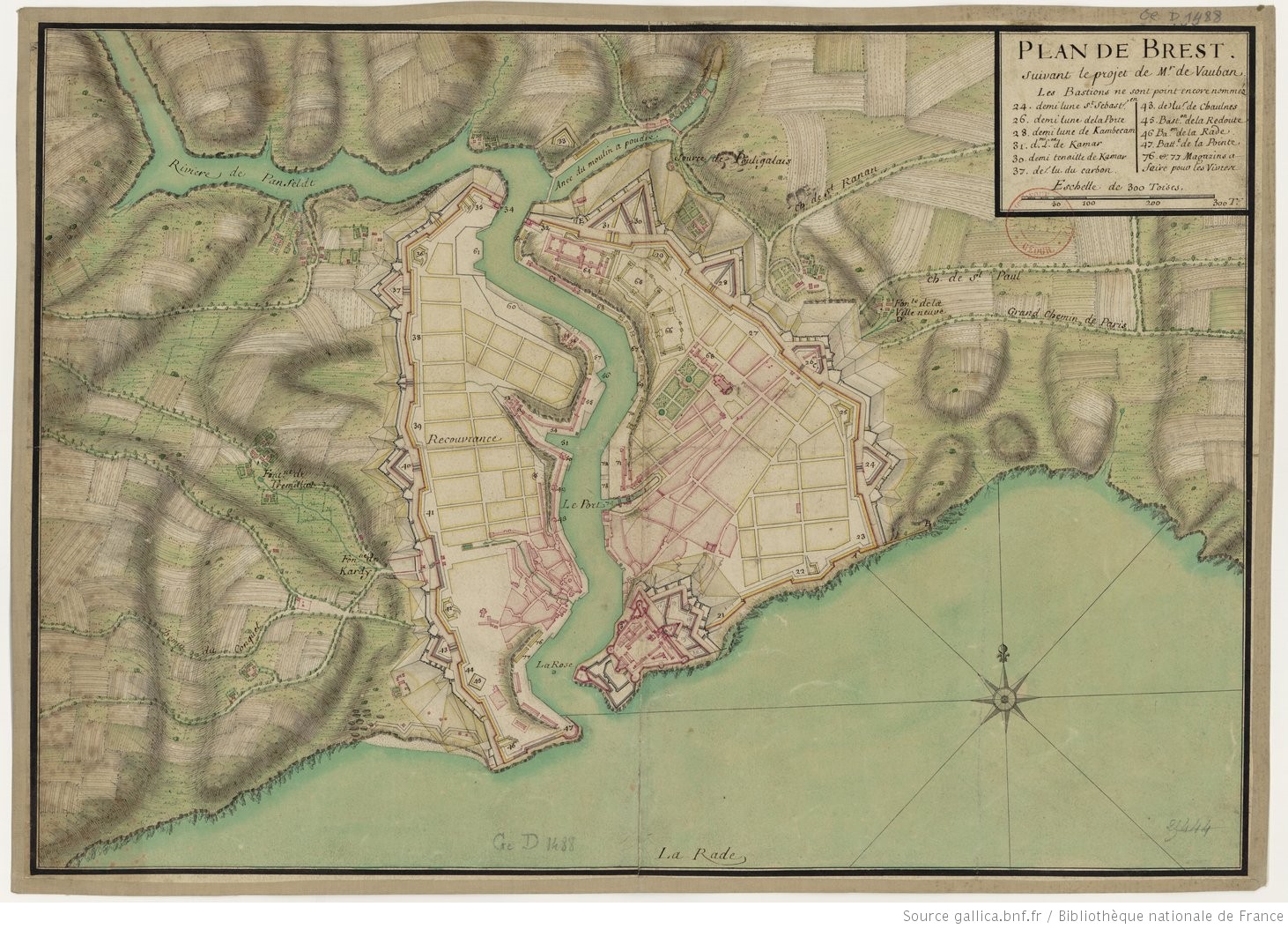
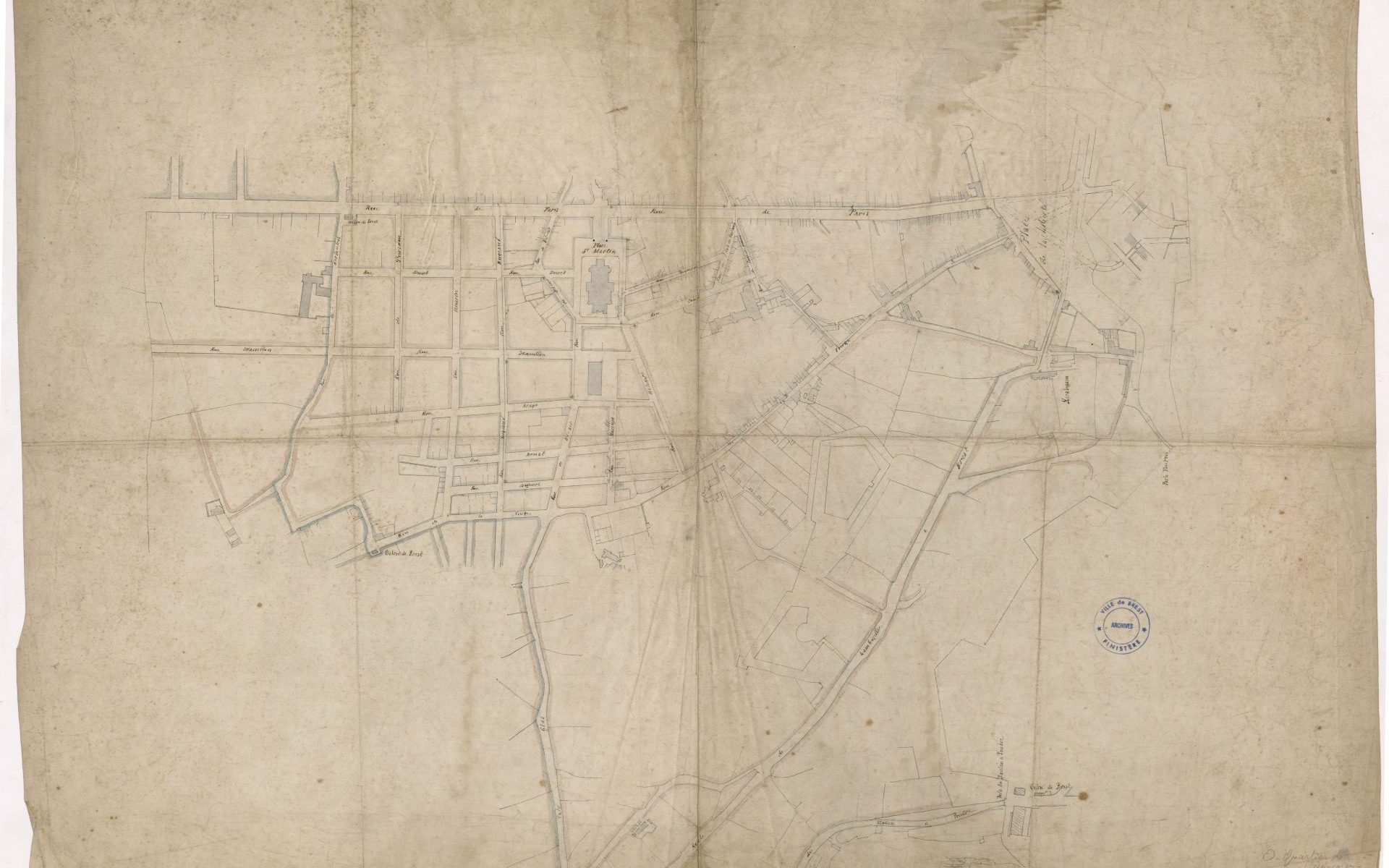
Plan de Brest et de ses environs, relatif aux projets pour l’agrandissement de l’enceinte, 1790 par Jean-Nicolas Desandrouins ingénieur, directeur à Brest des places de Bretagne (cote : 5Fi1113).

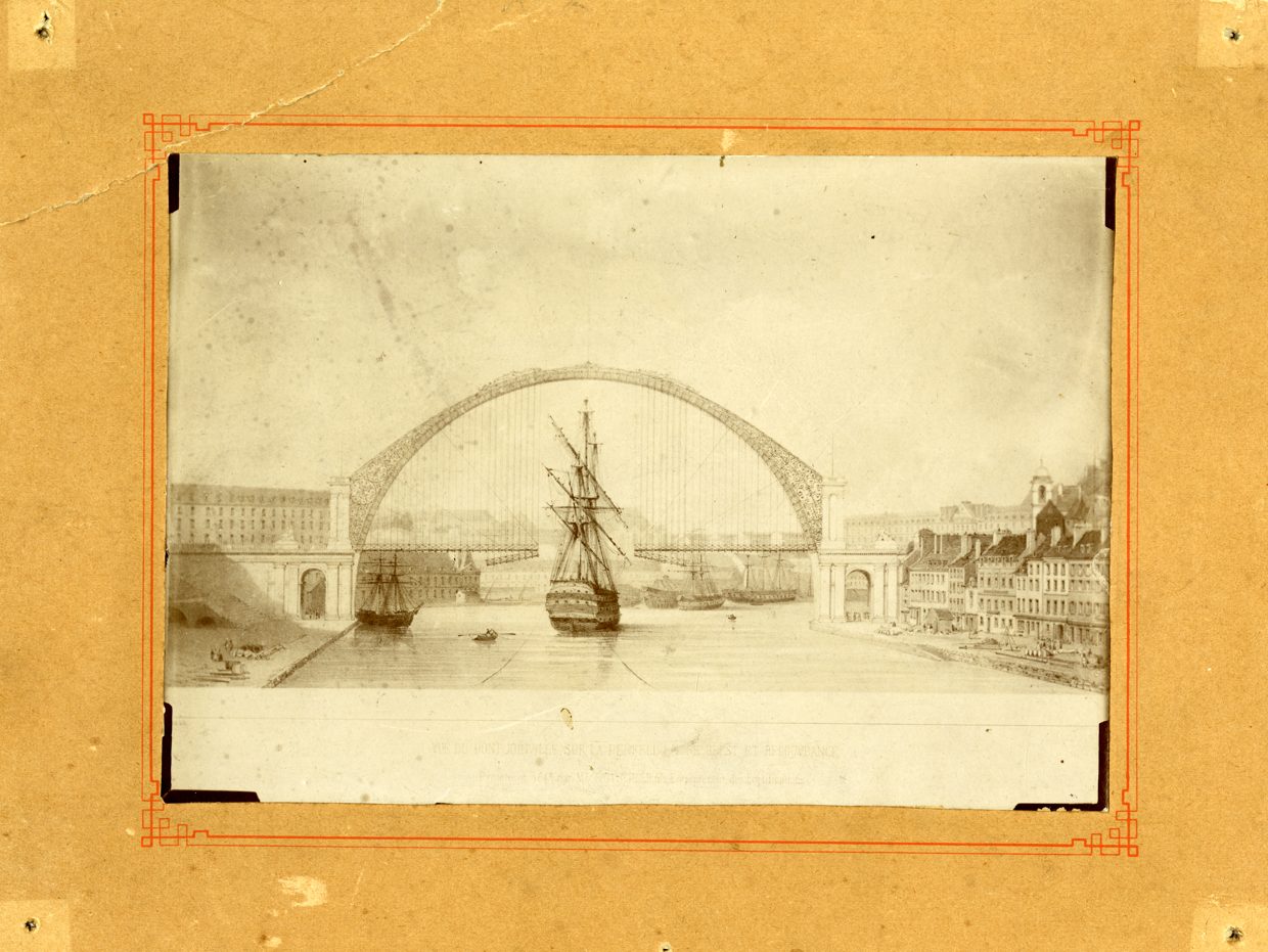
Joseph-Victor Tritschler, Projet non réalisé du pont à Brest (Penfeld), 19e siècle, 1843 (cote : 2 Fi 00409).

Pont tournant de Brest à Recouvrance, 1880 (cote : 2005.5.4).

L’Arsenal de Brest, sans date (cote : 12Fi2110).

Carte postale : vue sur l’arsenal, les bâtiments, des navires, la grande grue, la porte Tourville, le bassin à droite la rue Louis Pasteur, le centre ville de Brest, en arrière plan le clocher de l’église Saint Louis (cote : 12Fi2109).

Carte postale : Rue de Siam avant-guerre (cote : 3Fi019-018).

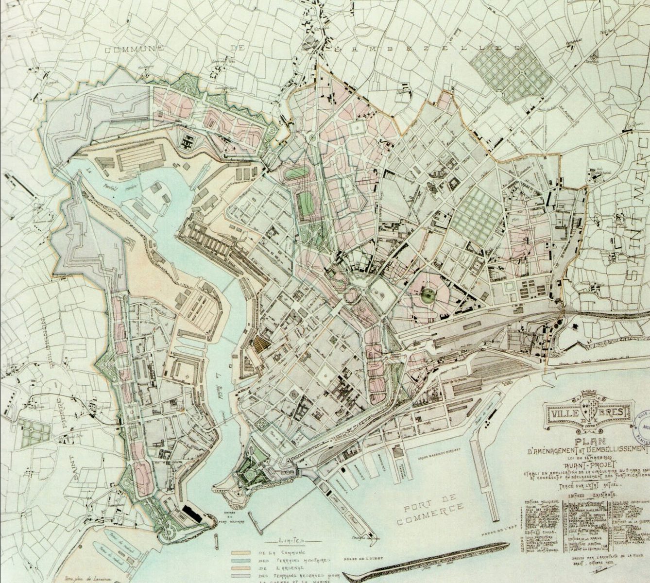
Georges Milineau, Plan d’aménagement, d’embellissement et d’extension de la ville de Brest, 1920 (cote : 5Fi760 ou 5Fi761).

Planimètre de la ville de Brest, 1937 (cote : 5Fi838).

Le Pont national ou Grand Pont, Destruction : vue du tablier plongeant dans la Penfeld, en arrière-plan les ruines à Recouvrance, 1945 (cote : 2Fi05175).

Jean-Baptiste Mathon, Plan de reconstruction et d’aménagement, 1948 (cote : 5Fi881).

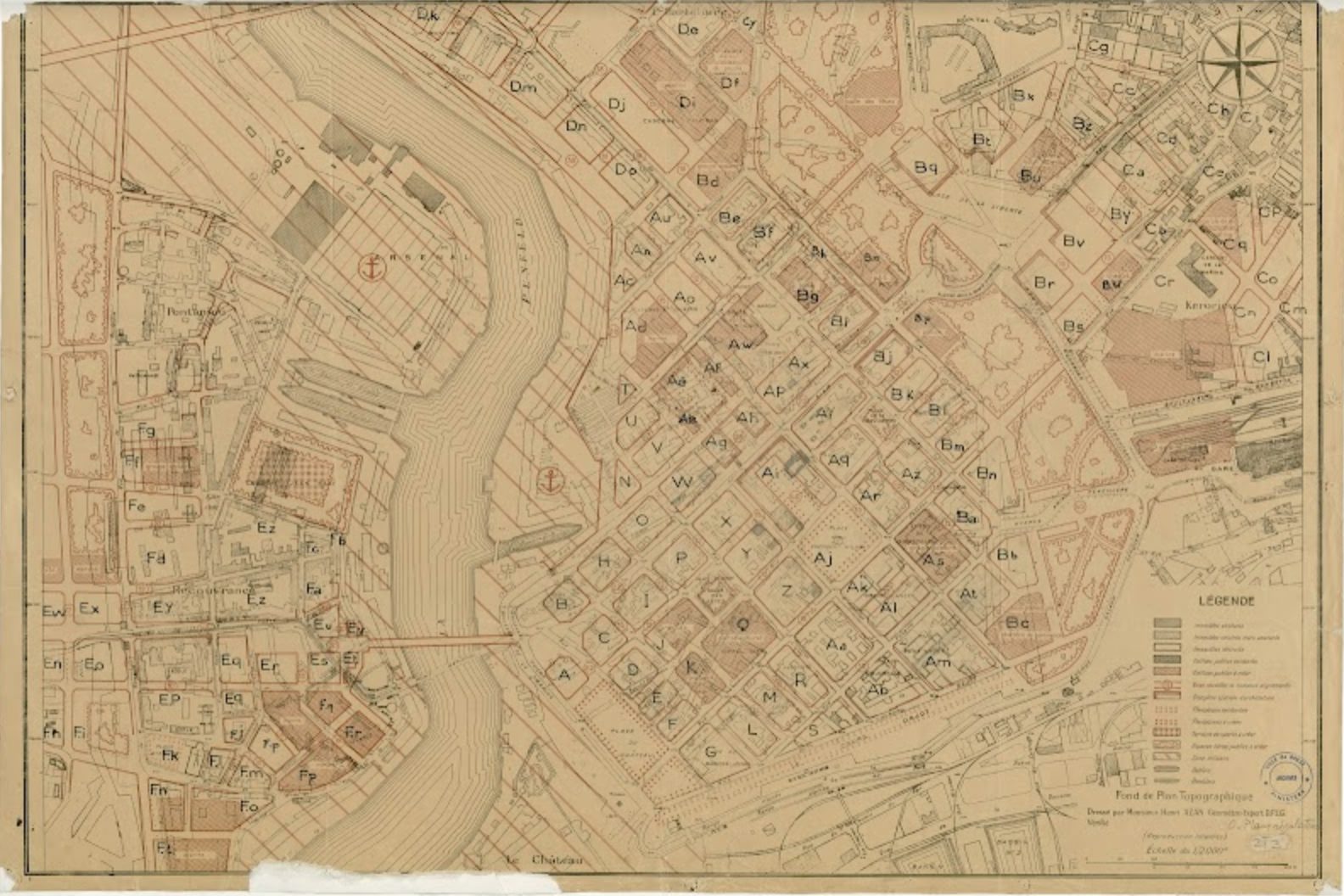
Plan de Brest, 1956 (cote : 5Fi897).

Rue de Siam, années 1950 (cote : 3Fi019-094).

Bijouterie Gouriou immeuble mer 33 Rue de Siam à Brest, (07/1950), Façade : élévation (cote : 5Fi2081).

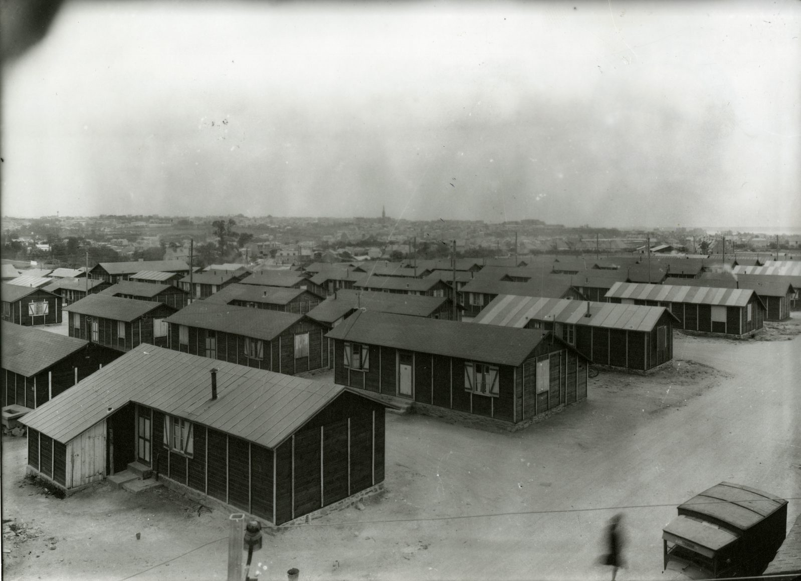
Cité commerciale dans les baraques (cote : 2Fi02823).

Baraques de Keredern, vers 1950 (cote : 2Fi02827).

Baraques du Polygone à Brest (cote : 2Fi12242).

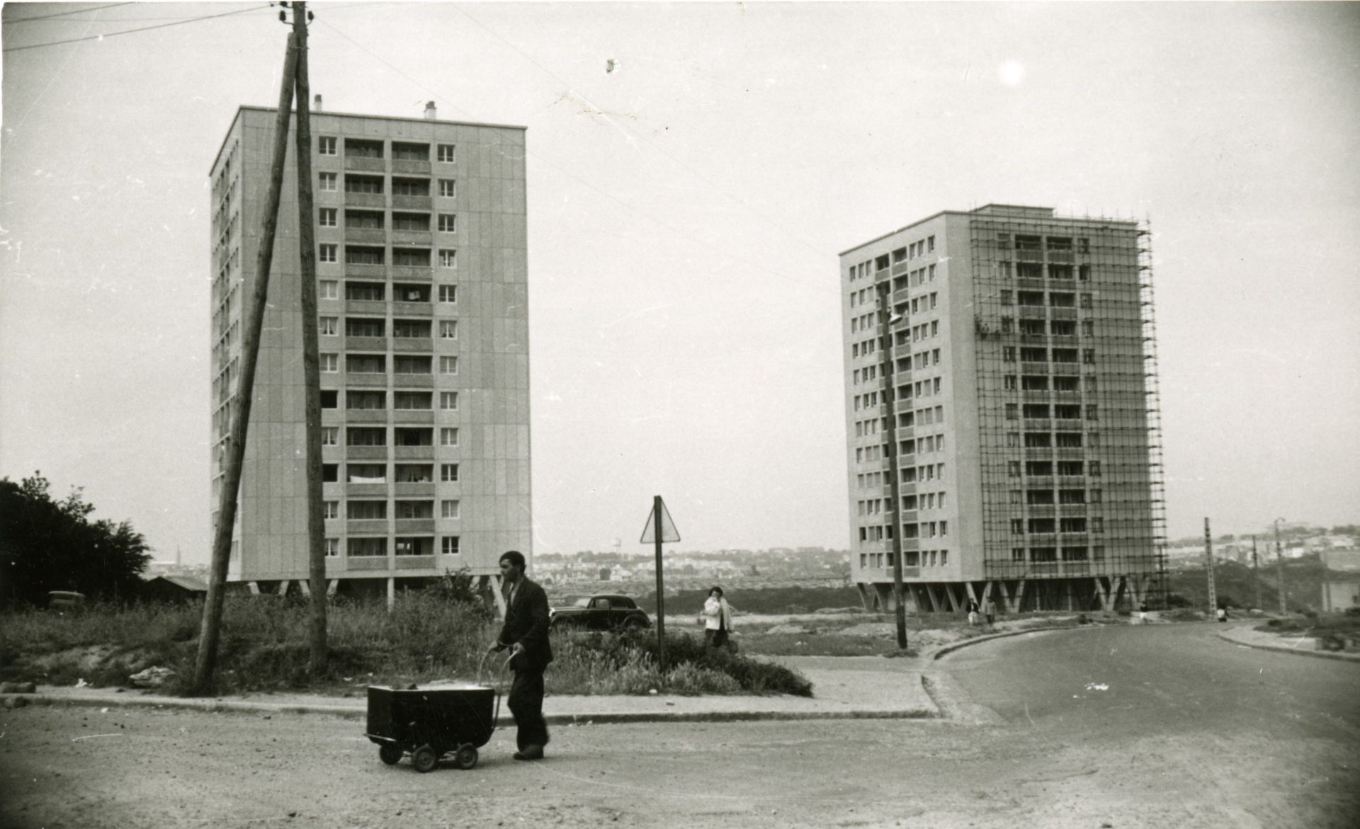
Tours de Quéliverzan en construction, Brest, 1954 (cote : 2Fi03155).

La construction du pont de l’Harteloire, 1950, photo Studio Le Bigot – St Pierre, Brest (cote : 2Fi10236).

Association Vivre la rue :

Photographies de la rue Saint-Malo investie par l’association Vivre la rue.

Brest Métropole :

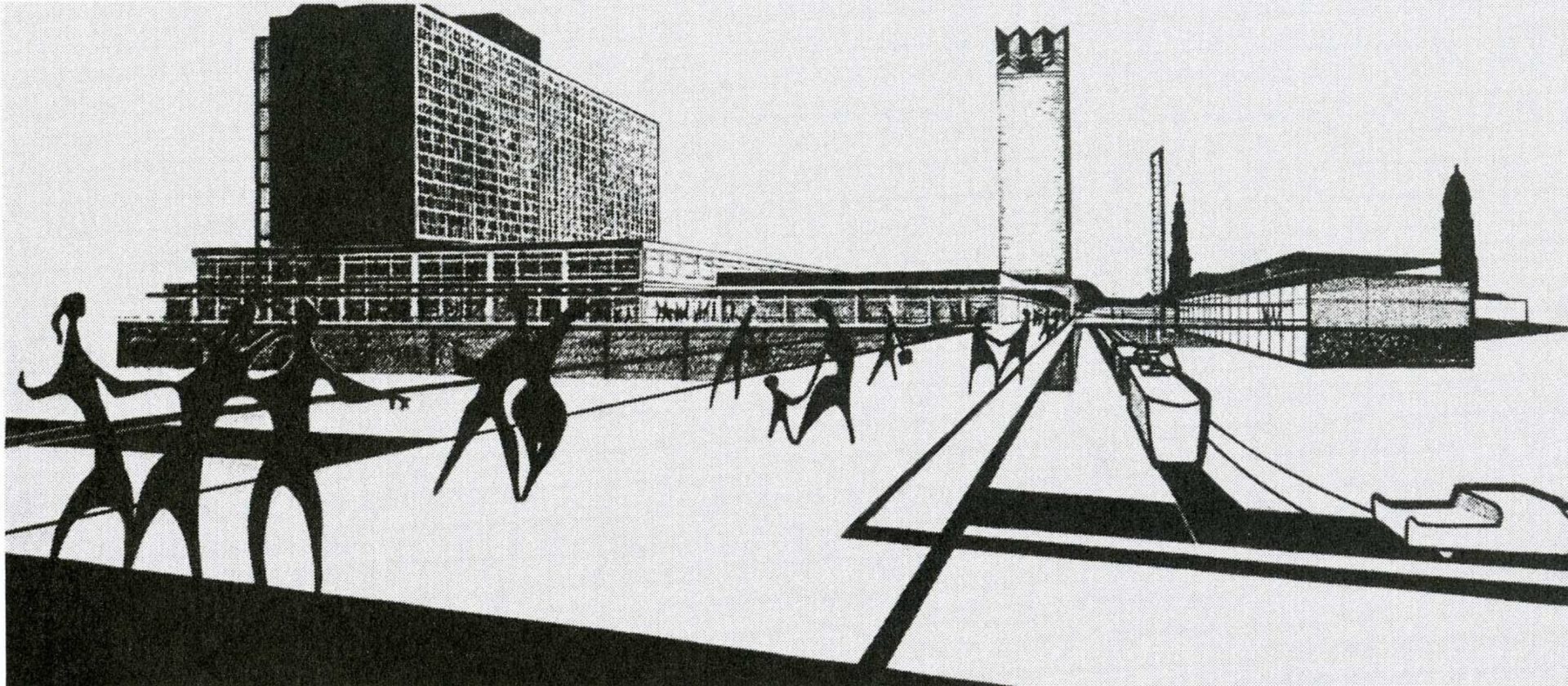
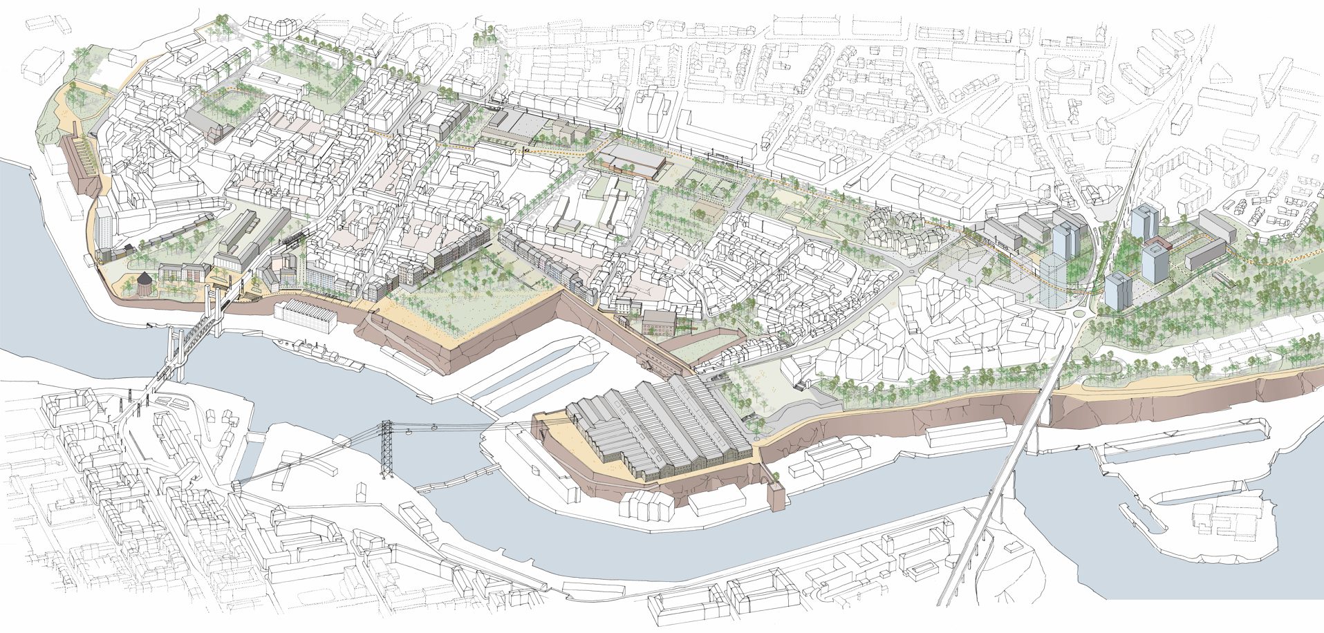
Agence ABC (Stéphane Füzesséry & Paul Landauer), Dessin du projet Grand Balcon, 2022.

Musée des Beaux-Arts Brest métropole : 

Louis-Nicolas Van Blarenberghe (Lille, 1716 – Fontainebleau, 1794), Vue du port de Brest (vue prise de la terrasse des Capucins) (inv. 981.18.1), 1774, huile sur toile, 125,5 cm x 194 cm.

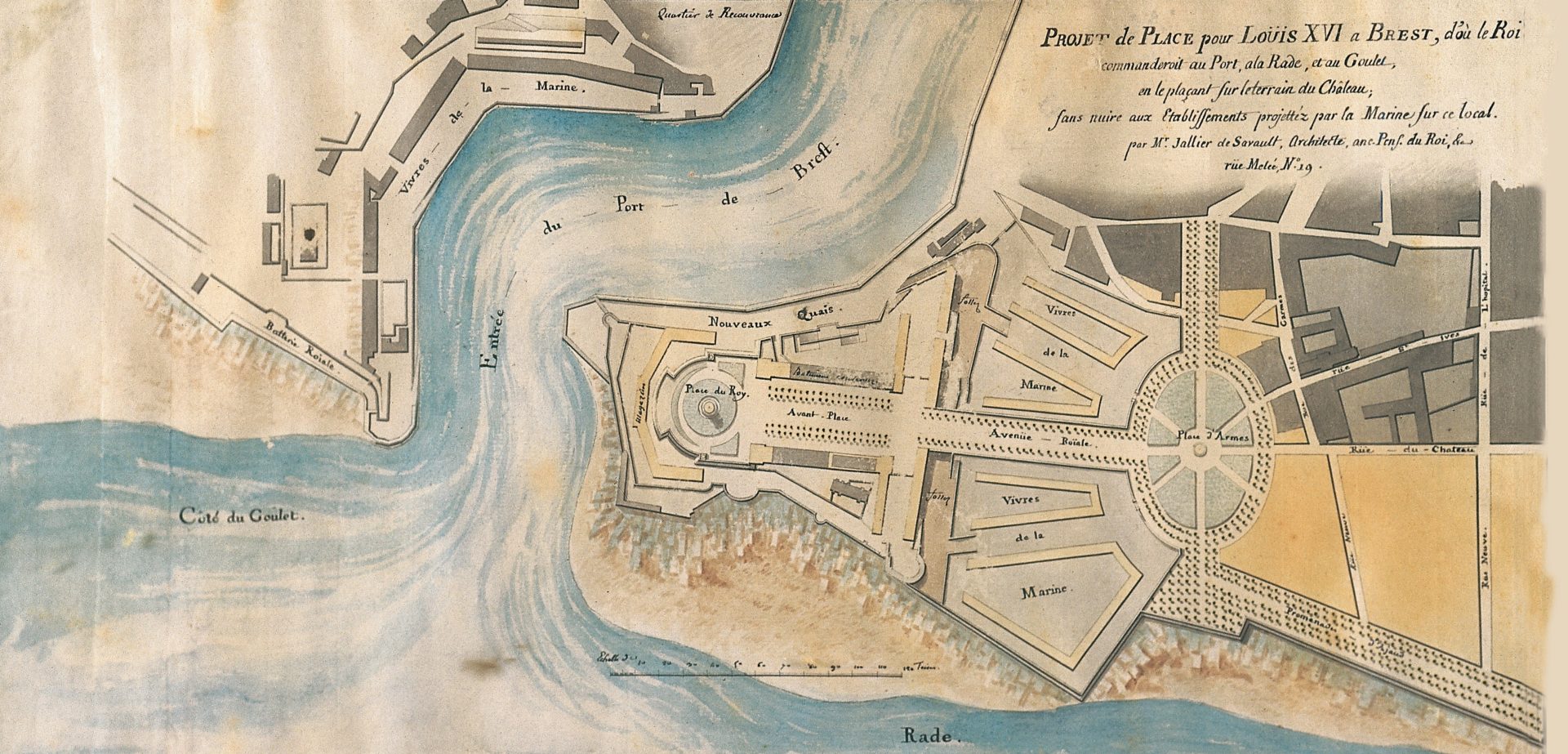
Claude Jean-Baptiste Jallier de Savault (?, 1738 – Paris, 1807), Projet de place Louis XVI à Brest (inv. 979.3.1), 4/4 du XVIIIème siècle, aquarelle et encre noire sur papier, 35,2 cm x 64,6 cm.

Georges Muller, d’après Alfred Guesdon (Nantes 1808 – Nantes, 1876), Brest, vue générale du Port prise de la Rade (série Voyage aérien en France) (inv. 964.5.1), vers 1850, lithographie sur papier, 40,1 cm x 56,6 cm.

Charles Villemin, d’après Alfred Guesdon (Nantes 1808 – Nantes, 1876), Brest, vue de la Ville et de la Rade prise des Glacis (série Voyage aérien en France) (inv. 960.13.25), vers 1850, lithographie aquarellée sur papier, 54,9 cm x 75,1 cm.

Autres / Collections particulières (France) :

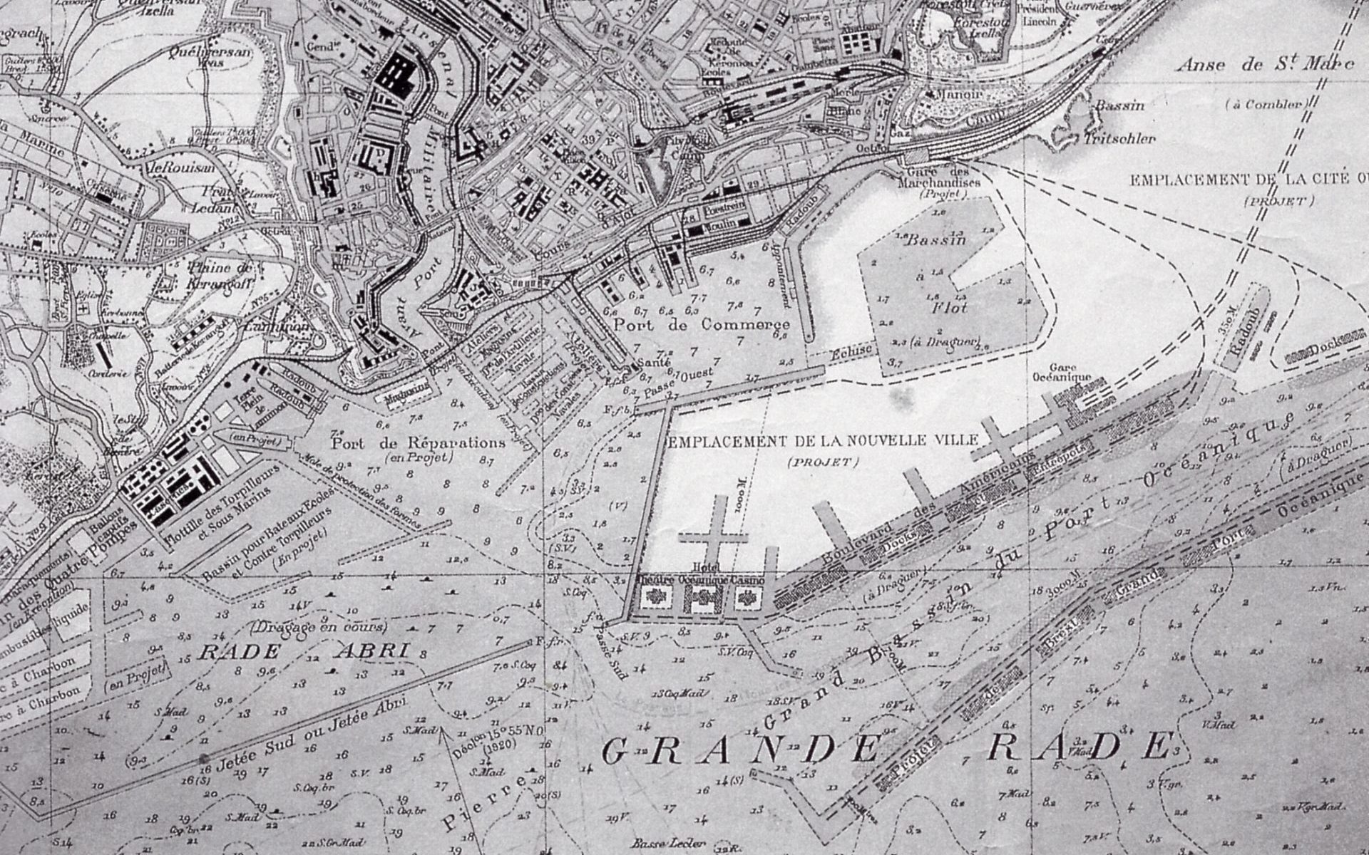
Brest, port océanique, plan commercialisé en 1919.

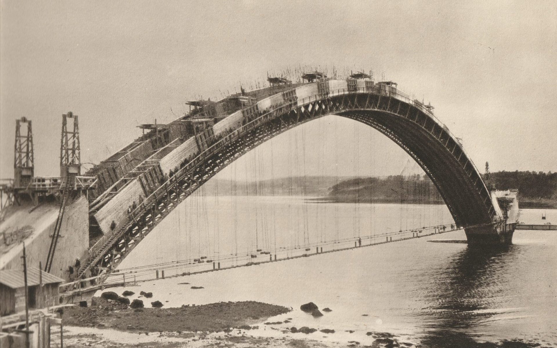
Eugène Freyssinet, Pont Albert Louppe, photographie des années 1930.

Construction du pont Albert-Louppe, de la brochure Le pont Albert Louppe, Finistère, éditée par la Société anonyme des entreprises Limousin en 1930.

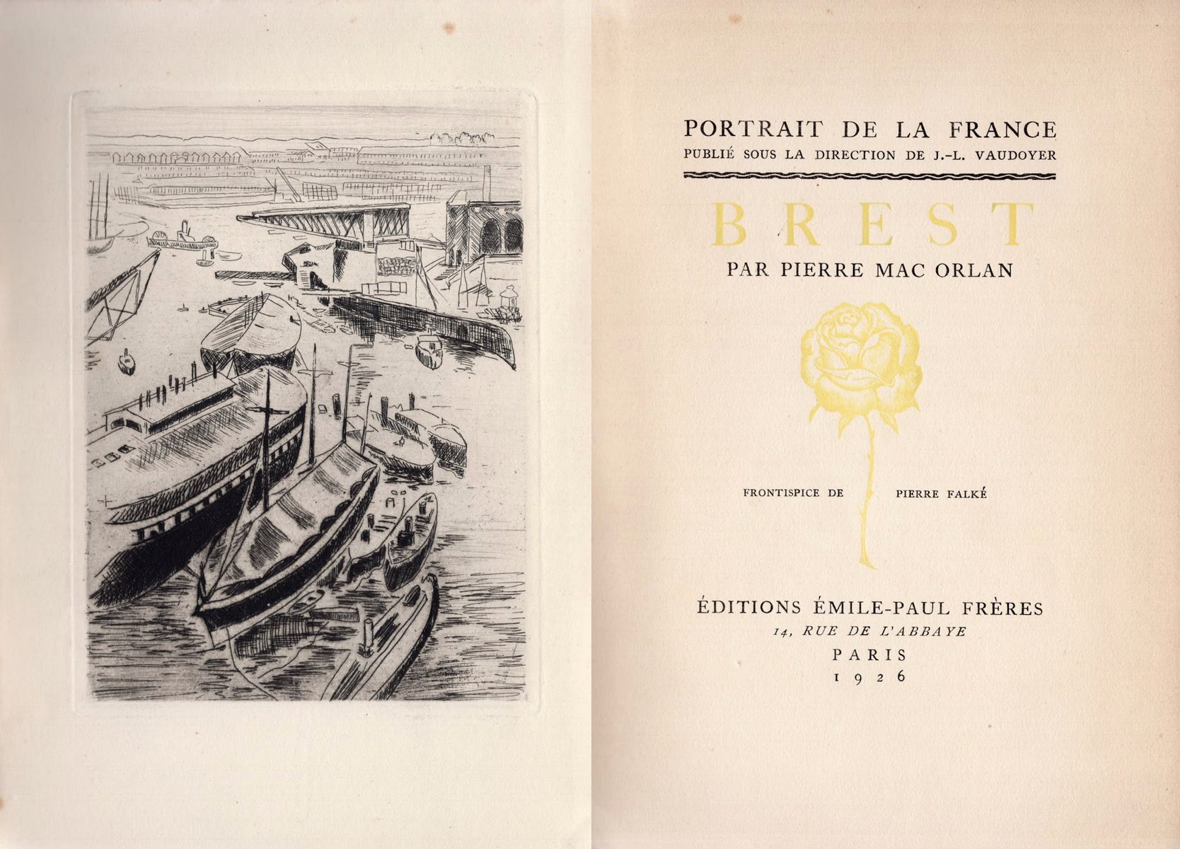
Frontispice du livre Brest écrit par Pierre Mac Orlan, gravure de Pierre Falké, 1926, Paris, éd. Emile-Paul frères.

Gare de Brest, arch. Urbain Cassan, 1937, photographie argentique.

Brest en ruines, au lendemain du siège, 1944, photographie argentique.

Brest après la guerre, photographie argentique.

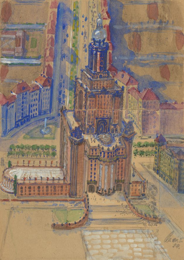
Jean-Baptiste Mathon, Place de la Trésorerie, Brest, dessin aquarellé, 1948, originaux perdus.

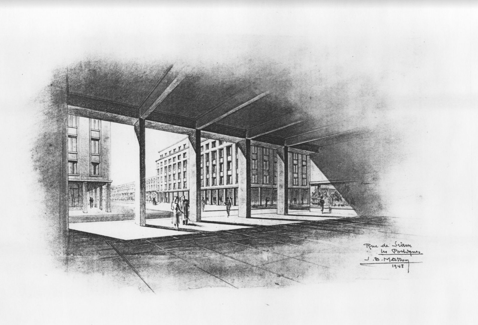
Jean-Baptiste Mathon, Rue de Siam, les Portiques, Brest, dessin aquarellé, 1948, originaux perdus.

Place de la Liberté et perspective de la rue de Siam vues de l’Hôtel de ville, années 1980, photographie argentique.

Anonyme, Proposition pour la place de la Liberté et le square Mathon, Concours d’idées, dessin, 1980, ADEUPA.

Yves Steff & Maxime Giraud-Mangin, New York’s sister, projet pour le Concours d’idées, dessin, 1980.

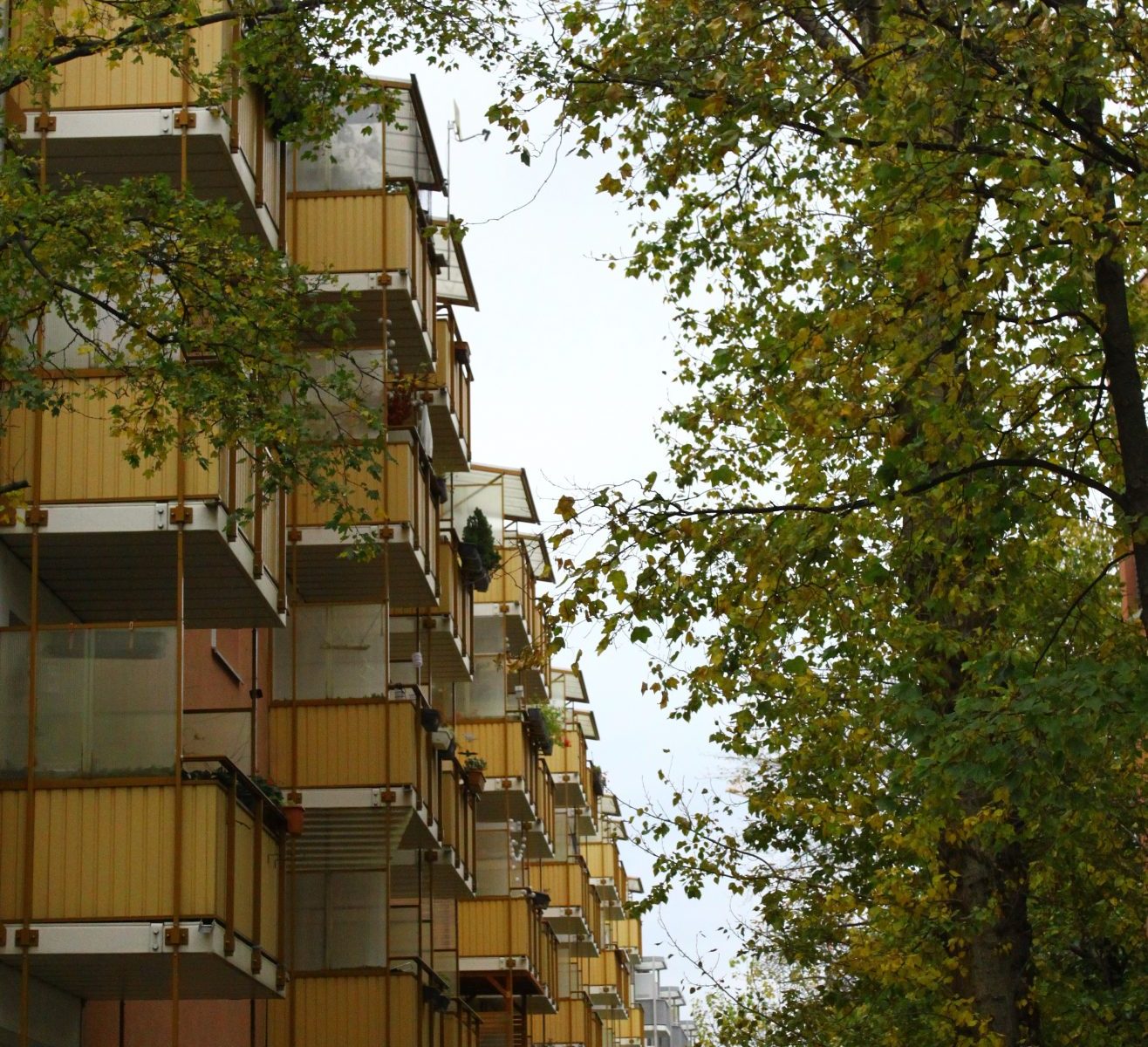
Renovierte Fassaden von Wohnblöcken aus der sozialistischen Ära, Dresden, Foto Quentin Arnaud, 2021.

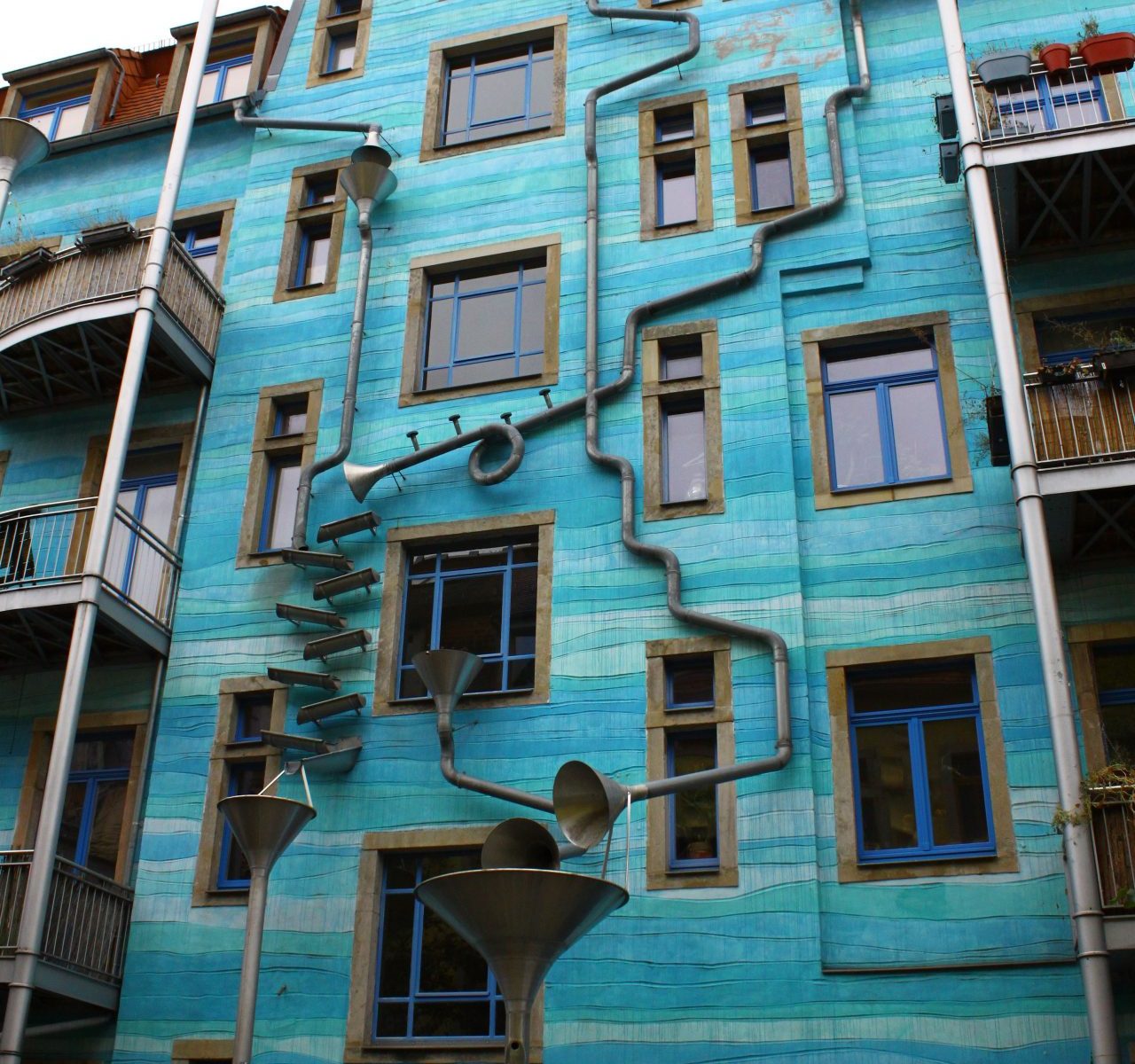
Kunsthofpassage, Neustadt, Dresden, Arch. Heike Böttcher, 1999, photographies numériques 2022.

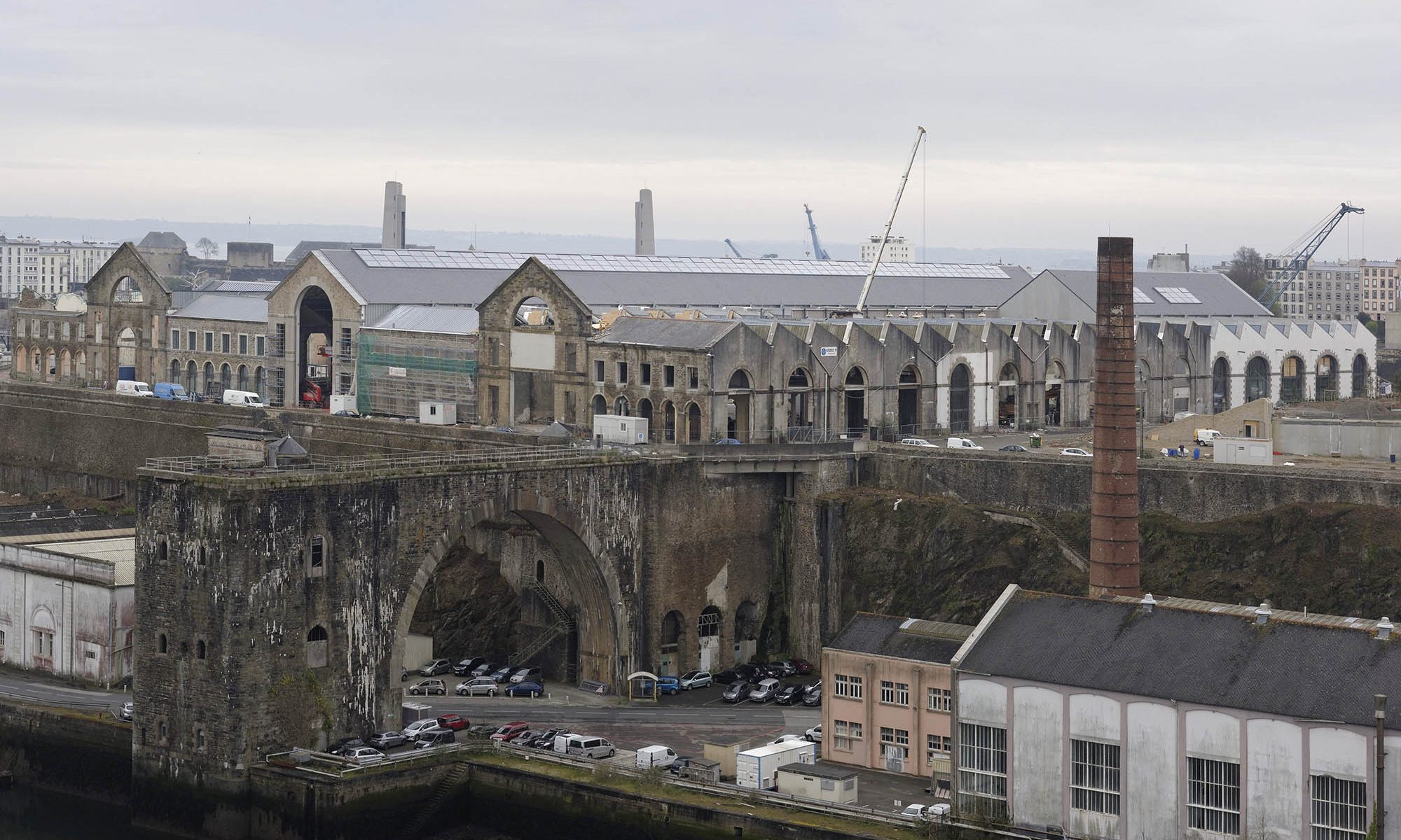
Jean-François Mollière, Le Plateau des Capucins en travaux, avril 2016.

Frédéric Le Mouillour, Brest. Quartier de Kérigonan, 2013.

Stéphane Couturier, Place Georg Treu à Dresde, photographie de la série Archéologie urbaine, 1997.

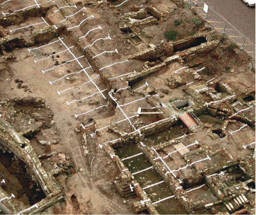
Gwenaëlle Magadur et Sylvain Le Stum, La ville en mutation, 2006-2011, Proposition d’installations sur les rives de la Penfeld, Dessins des origines du quartier de Recouvrance, rive droite et du quartier des Sept Saints, rive gauche. Dans le cadre de la résidence conjointe plasticien/architecte, soutenue par la DRAC Bretagne et la ville de Brest.

Gwenaëlle Magadur, La carte de la Ligne bleue, 2006, La carte de la Ligne Bleue, proposée en 2006 pour une forme pérenne, marque la « petite ceinture des remparts », historiquement antérieure à la grande. Rives droite et gauche de la Penfeld.

Gwenaëlle Magadur, La Ligne Bleue, Brest, 2000, Carrefour de la rue Antoine de Saint-Exupéry et Pierre Loti. Rive droite de la Penfeld. Place de la Liberté. Avenue Georges Clémenceau. Rive gauche de la Penfeld. Installation éphémère réalisée avec le soutien de la ville de Brest, du département du Finistère et de la région Bretagne, La Ligne Bleue marque la « grande ceinture des remparts ».

Wen2, Images de Brest : Le Vauban, La Recouvrance, Triskell.

Akademie der Künste Berlin:

Hans Scharoun, Entwurf zum Wettbewerb von 1920 für das Deutsche Hygiene-Museum, im Hintergrund der Zwinger, Baukunstarchiv der Akademie der Künste Berlin, Hans-Scharoun-Archiv Nr. 1228 Pl.28/11.

Architekturmuseum TU München:

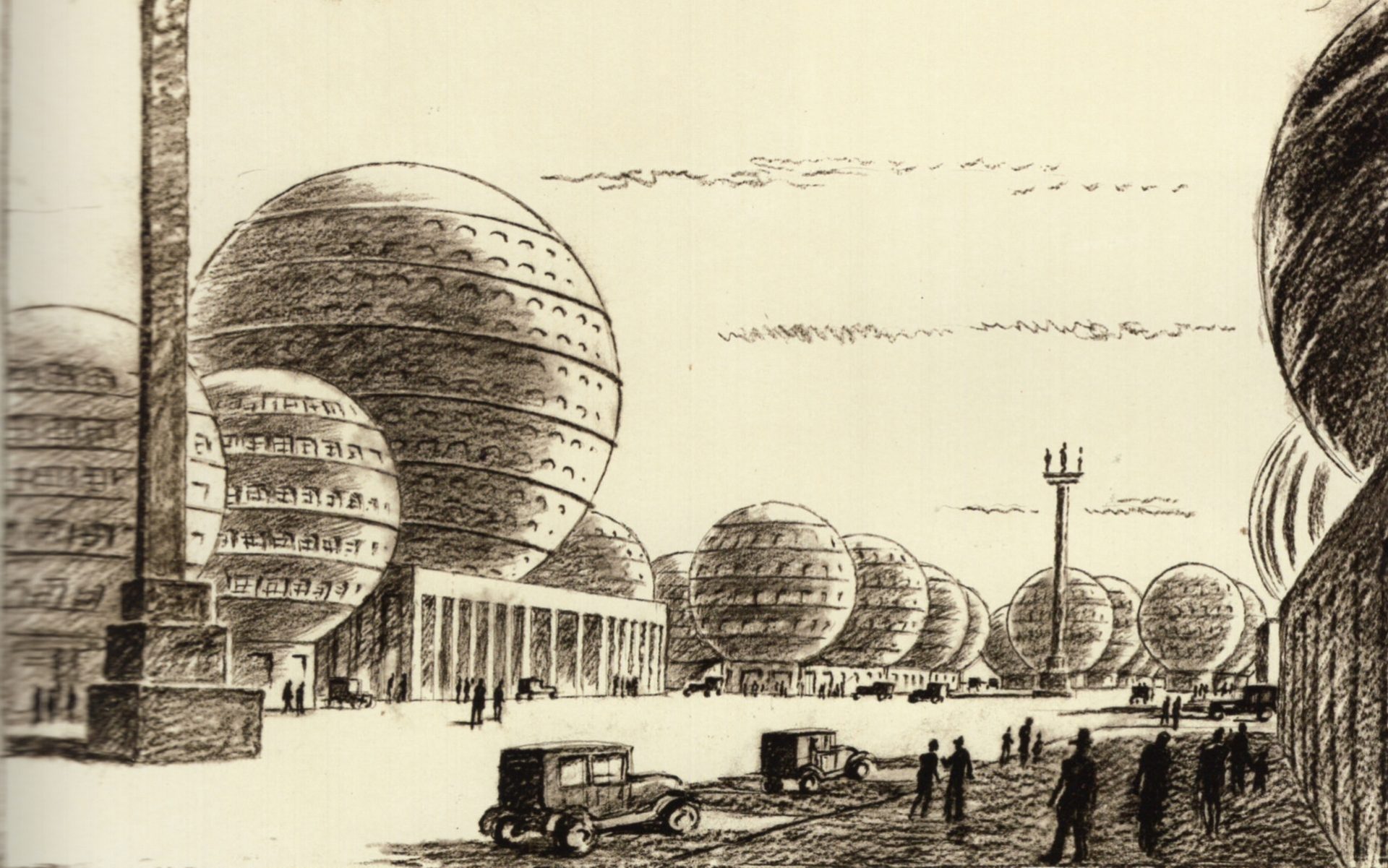
Peter Birkenholz, Zeichnung Kugelhausstadt, 1927, Architekturmuseum der TU München, Sign. bir-369-4.

Bundesarchiv Koblenz:

Ulrich Häßler, Kulturpalast Dresden (Arch. Leopold Weil & Klaus Wever, 1966-69), 1985, Bild_183-1985-0918-026.

Cinémathèque de Bretagne

Ce Brest dont il ne restait rien, Jean Le Goualch, 1944 à 1964, 16mm, noir et blanc, sonore, n°4597 : https://www.cinematheque-bretagne.bzh/base-documentaire-ce-brest-dont-il-ne-restait-rien-426-4597-0-1.html?ref=7538b411cc12adf993b5b55c8a450853.

Archives américaines 4 / 208-UN-1041, National Archives and Record Administration (at College Park) ,1942 à 1945, noir et blanc, sonore, n°25720 : https://www.cinematheque-bretagne.bzh/base-documentaire-archives-américaines-4-426-25720-0-1.html?ref=eb1dcbdc0efa0f8dd11cffb4a0e6adfb.

Gemäldegalerie Alter Meister Dresden:

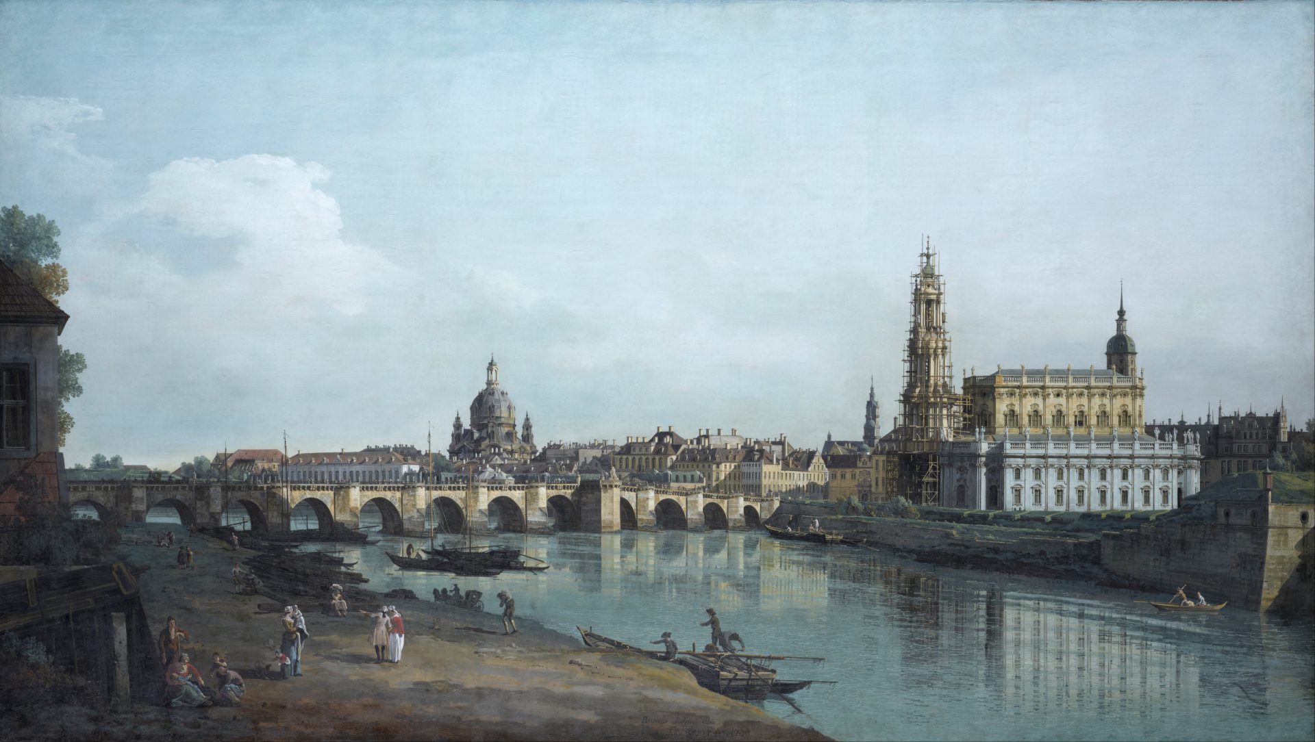
Bernardo Bellotto, genannt Canaletto oder Canaletto der Jüngere, Dresden vom rechten Ufer der Elbe aus gesehen, unterhalb der Augustusbrücke, 1747, Öl auf Leinwand.

Bernardo Bellotto, genannt Canaletto oder Canaletto der Jüngere, Ansicht von Dresden. Der Neumarkt in Dresden vor Jüdenhofe, mit Frauenkirche im Hintergrund, 1748, Öl auf Leinwand.

Hygiene-Museum Dresden:

Gussy Hippold-Ahnert, Badeanstalt am Blauen Wunder, 1935, Aquarell, DHMD 1995/56.

Landesamt für Denkmalpflege Sachsen:

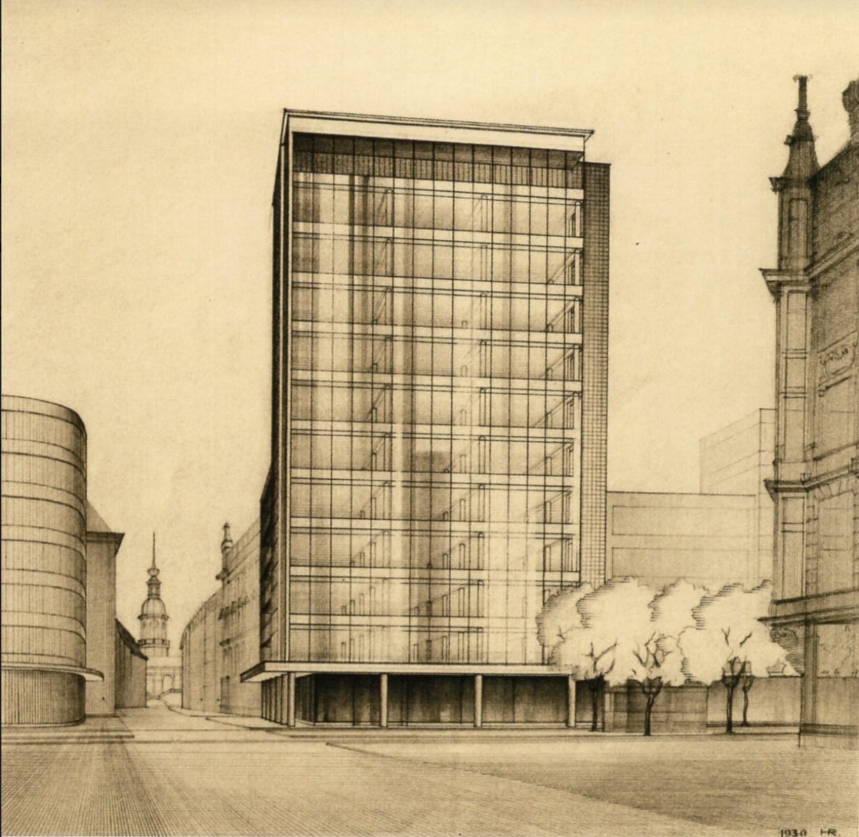
Hans Richter (14.04.1882 Königswalde/Böhmen – 10.12.1971 Dresden), Dresden, Hochhaus am Pirnaischen Platz, Ansicht von Osten mit Umgebung (angeschnitten), um 1930, bezeichnet in der Darstellung u. r. mit Bleistift „1930 HR.“ (ligiert), auf dem Blatt u. l. auf aufgeklebtem Papier maschinenschriftlich „hochhaus pirnaischer platz // blick von der grunaer straße“, Bleistift auf Zeichenkarton, Blatt 69,8/70,0 cm x 49,4/49,7 cm (unregelmäßig), LfD Sachsen, Plansammlung, Inv.-Nr. 2019/1.

SLUB Dresden Deutsche Fotothek:

Hahn, Walter: Dresden. Hauptbahnhof. Gleisanlagen, Empfangsgebäude., Bahnsteighalle. Luftbild-Schrägaufnahme von Südosten, 1925.05, Aufn.-Nr.: df_hauptkatalog_0304975, Negativ (Glas, 4 x 5 inch, schwarzweiß).

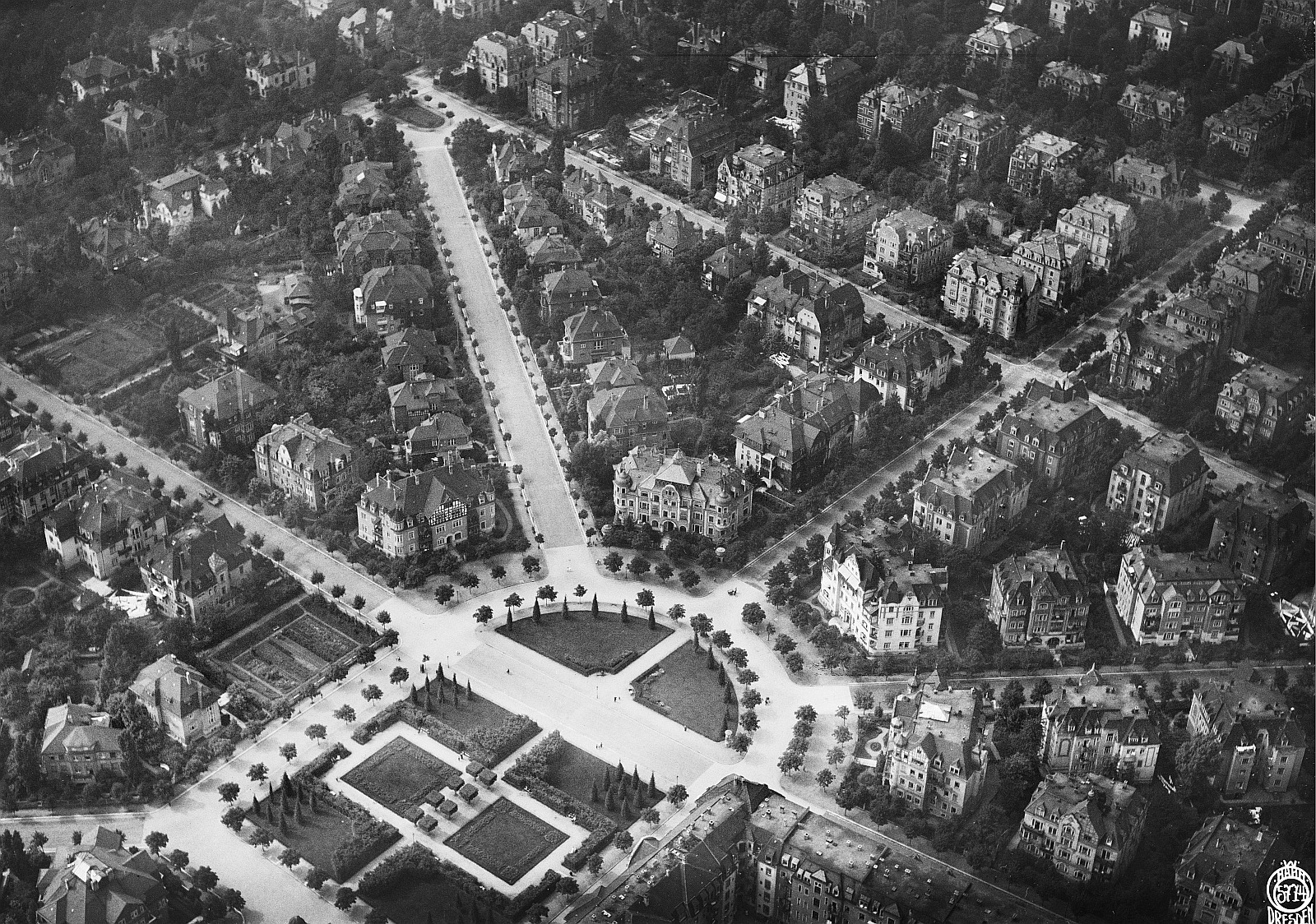
Hahn, Walter: Dresden-Striesen. Stadtteilansicht mit Waldersee-Platz (Stresemannplatz). Luftbild-Schrägaufnahme von Osten, 1924, Aufn.-Nr.: df_hauptkatalog_0305774, Originalnegativ (Glas, 10 x 15 cm, schwarzweiß).

Hahn, Walter: Dresden. Blick vom Rathausturm mit Skulptur auf die zerstörte Innenstadt, 1945, Aufn.-Nr.: df_hauptkatalog_0314636, Negativ (Glas, 13 x 18 cm, schwarzweiß).

Hahn, Walter: Südvorstadt mit Landgericht, Blick nach Nordosten, 1932, Aufn.-Nr.: df_hauptkatalog_0310213, Originalnegativ (Glas, 13 x 18 cm, schwarzweiß).

Peter, Richard sen.: Dresden nach der Bombardierung vom 13./14. Februar 1945, nach 1945.09.17, Aufn.-Nr.: df_ps_0000364_001, Originalnegativ (Kunststoff (Zellulosenitrat), 24/36 mm, schwarzweiß).

Peter, Richard sen.: Dresden. Zerstörtes Lutherdenkmal vor der Ruine der Frauenkirche, nach 1945.09.17, Aufn.-Nr.: df_ps_0000385_001, Originalnegativ (Kunststoff (Zellulosenitrat), 3/4 cm, schwarzweiß).

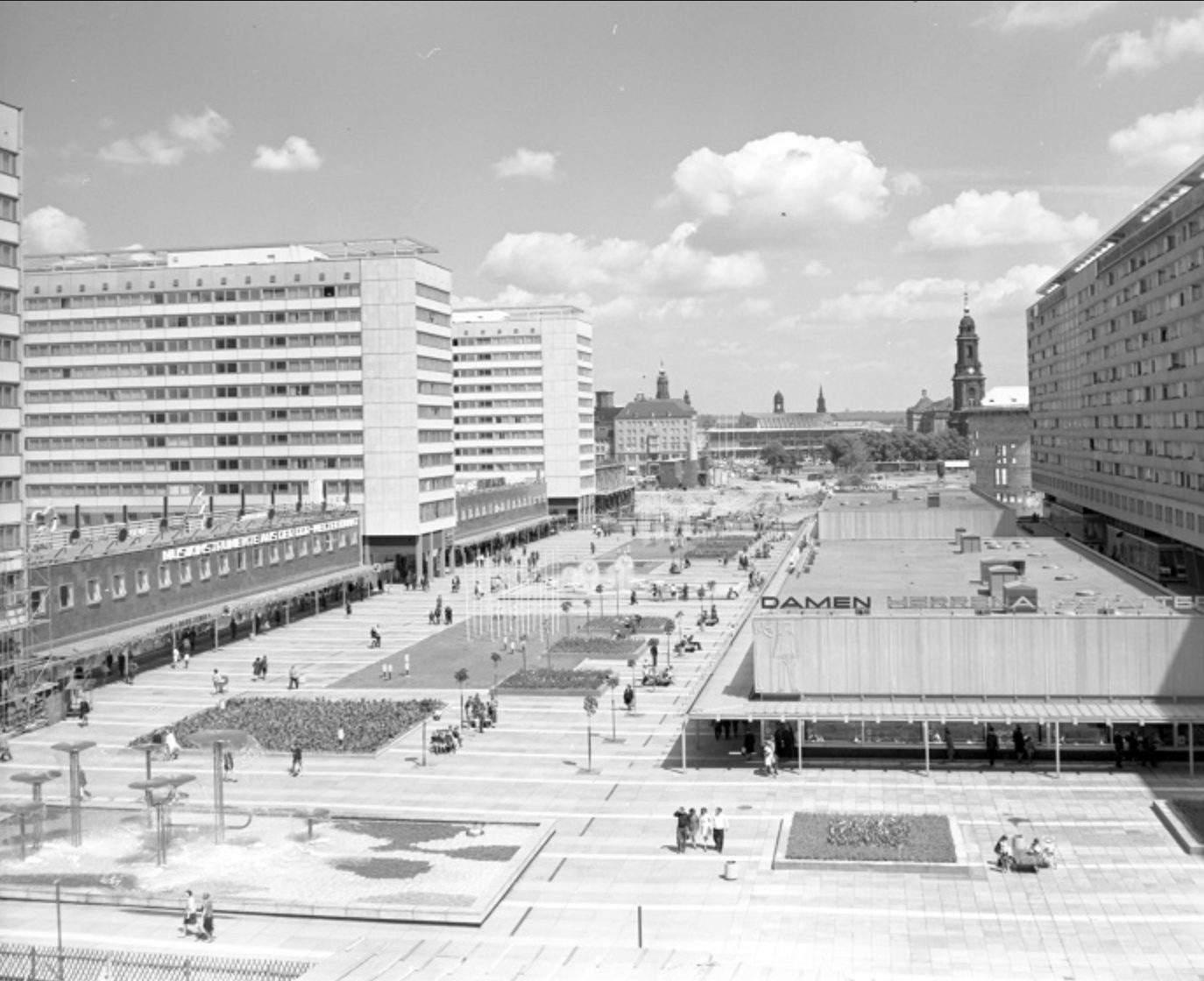
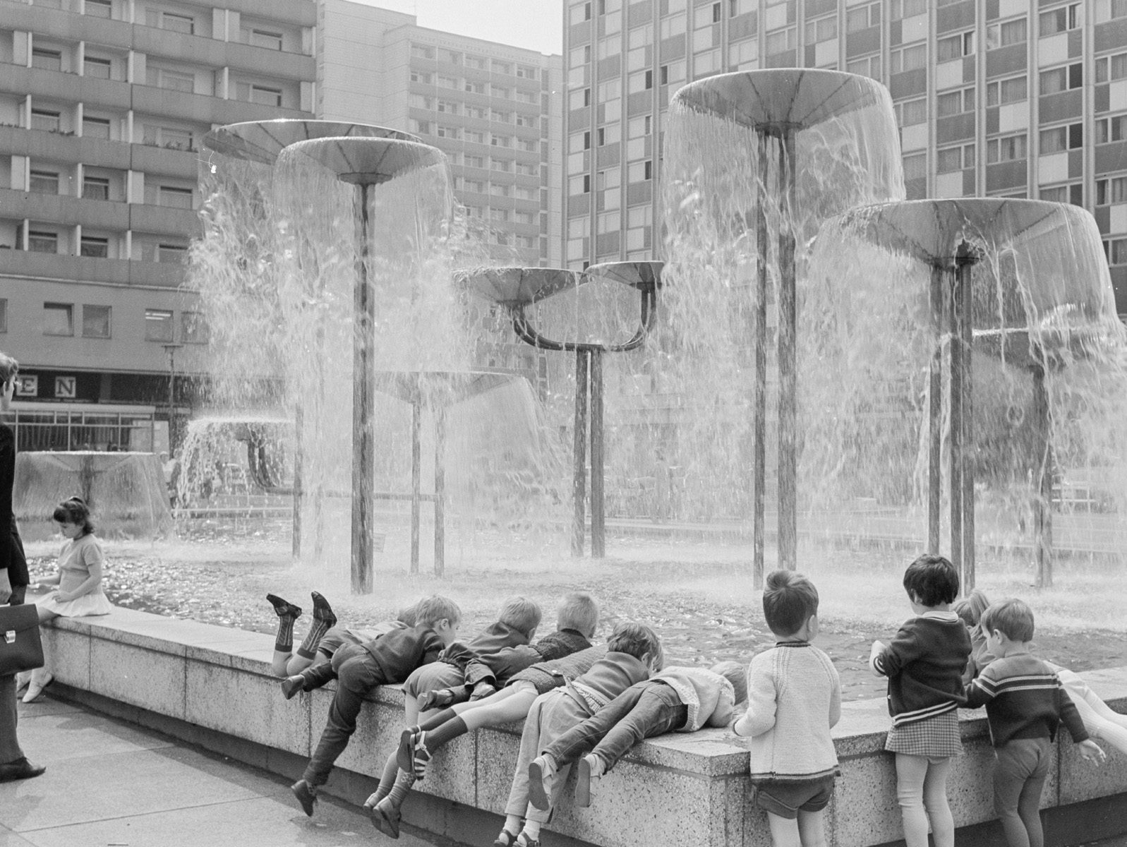
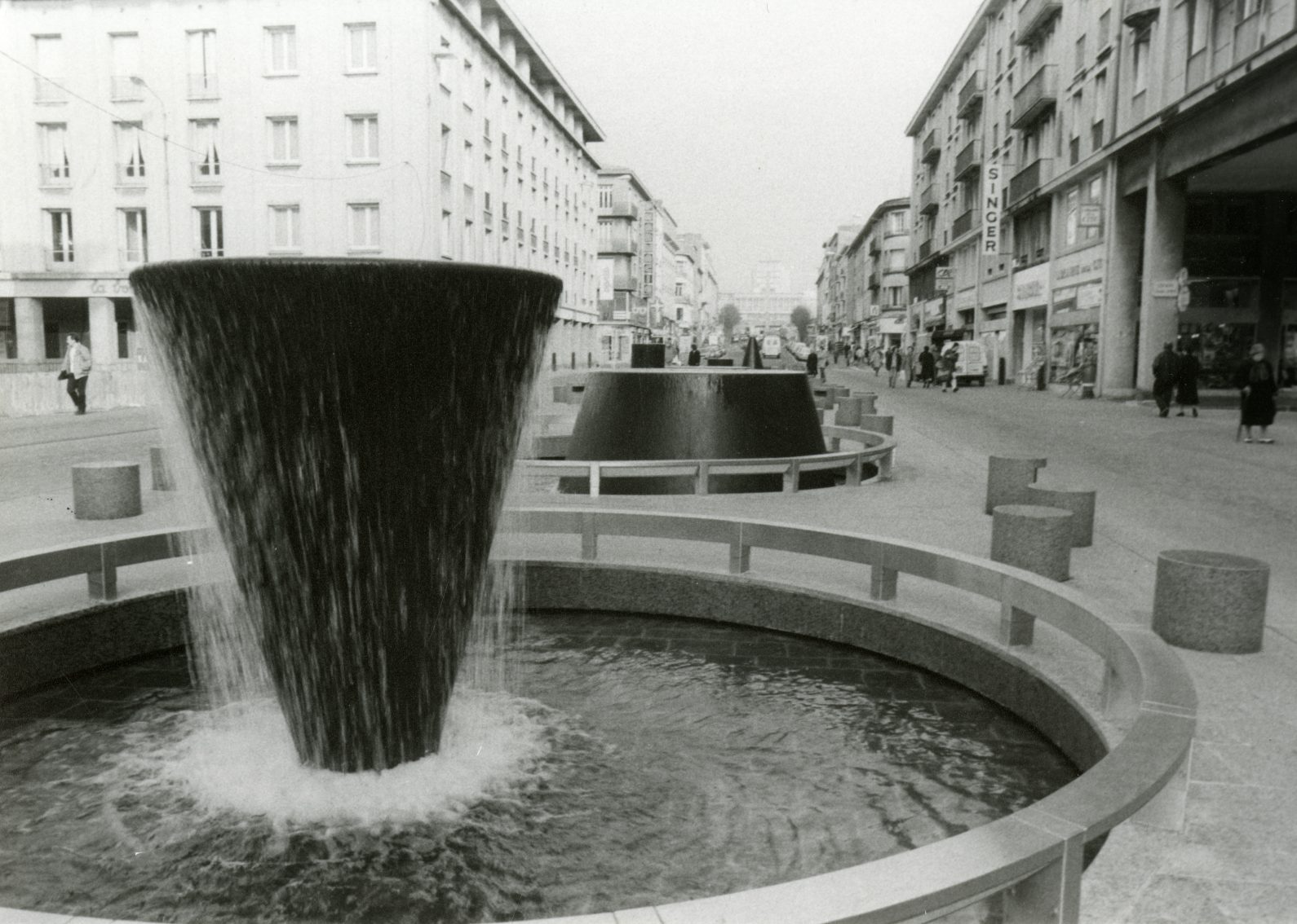
Peter, Richard sen.: Pragerstraße, Pusteblumenbrunnen / Am Pusteblumen Brunnen, 1968, Pragerstr., Aufn.-Nr.: df_ps_0002955, Originalnegativ (Kunststoff, 6/9 cm, schwarzweiß).

Peter, Richard sen.: Wasserspiel mit Schalen, um 1975, Aufn.-Nr.: df_ps_0001024, Originalnegativ (Kunststoff, 6/6 cm, schwarzweiß).

Peter, Richard sen.: Blick zum Interhotel “Newa” (links; 1968-1970; C. Kaiser, M. Arlt, H. Fuhrmann, J. Weinert) und zu Appartementhochhäusern (1965-1966; J. Kaiser, P. Schramm), 1973, Aufn.-Nr.: df_ps_0001006, Originalnegativ (Kunststoff, 6 x 6 cm, schwarzweiß).

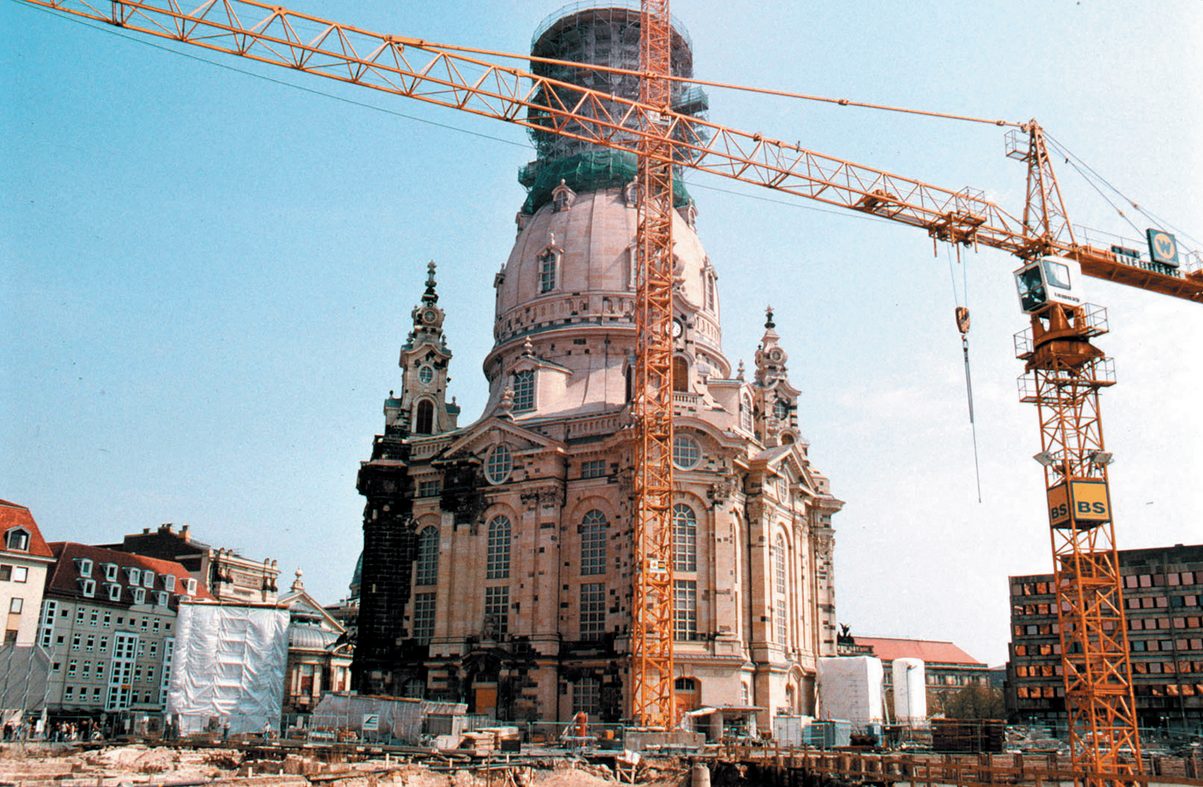
Bauwerk: Frauenkirche, Aufn.-Nr.: df_hauptkatalog_0138038, Negativ (schwarzweiß).

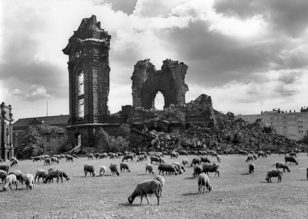
Möbius, Walter: Ruine der Frauenkirche mit weidenden Schafen, Aufn.-Nr.: df_hauptkatalog_0135395, Reproduktionsnegativ (Kunststoff, 13 x 18 cm, schwarzweiß).

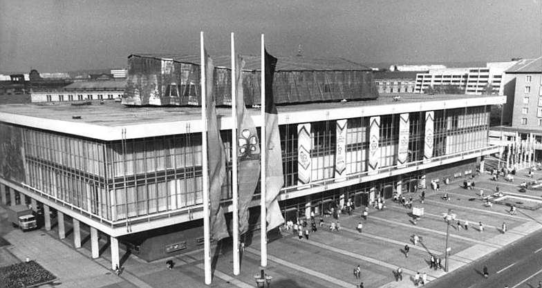
Bauwerk: Hotel Newa, Aufn.-Nr.: df_hauptkatalog_0188254, Originalnegativ (Kunststoff, 13 x 18 cm, schwarzweiß).

Johann Christoph Knöffel, Frauenkirche, Schnitt, ohne Datum (1720er Jahre), Landesamt für Denkmalpflege Sachsen, Repro Aufn.-Nr.: df_hauptkatalog_0050880, Negativ (schwarzweiß).


Meser, C.F.: Blick von der Brühlschen Terrasse auf die Hofkirche, Radierung, um 1825, Aufn.-Nr.: df_dk_0013303, Datensatz (color).

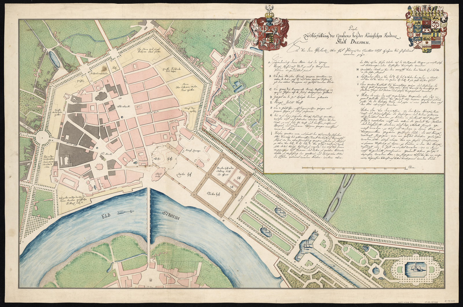
François de Cuvilliés der Ältere: Fiktive Planzeichnung zur Neubebauung Königlichen Residenz, Projekt zur Entfestigung von Dresden, Handzeichnung, um 1761, 2020, Aufn.-Nr.: df_dk_0013309, Datensatz (color), SächsHStA, 12884, Karten und Risse, F 145; Nr. 12a.

Pöppelmann, Dresden. Zwinger. Entwurf Torturm, 2006, Aufn.-Nr.: df_dz_0000001
Datensatz(color).

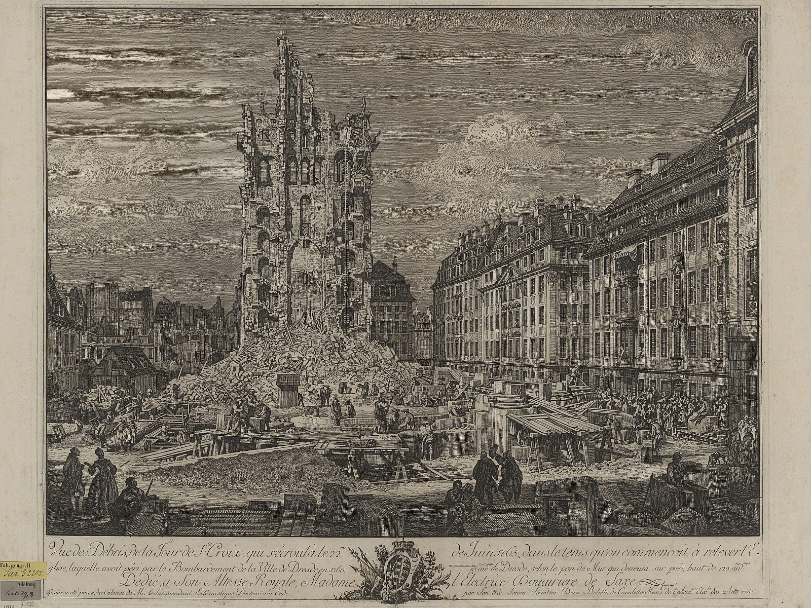
Bernardo Bellotto, genannt Canaletto oder Canaletto der Jüngere, Ansicht der eingestürzten Kreuzkirche in Dresden, 1765, Kupferstich ; 63 x 47 cm, Aufn.-Nr.: df_dk_0003827, Datensatz (color).

Bässler, Wilhelm: Ansicht vom Bau der Marienbrücke, Lithographie, 1849, Aufn.-Nr.: df_dk_0008829, Datensatz (color).

Reinecke, Hans: Panorama der Augustusbrücke und des Neustädter Ufers in Dresden, 1991, Aufn.-Nr.: df_hauptkatalog_0266677, Originalnegativ (Kunststoff, 13/18 cm, schwarzweiß).

Möbius, Walter: Dresden-Altstadt, Almarkt. Blick vom ehem. Modehaus Möbius über Baustelleneinrichtungen gegen Wohn- und Geschäftshäuser, Aufn.-Nr.: df_hauptkatalog_0127231, Originalnegativ (Glas, 13/18 cm, schwarzweiß).

Nagel, Heinz: Dresden, Ansicht vom Dach des Ständehauses über den Altmarkt nach Südsüdwest, 1957.05, Aufn.-Nr.: df_hauptkatalog_0134776, Originalnegativ (Glas, 13 x 18 cm, schwarzweiß).

Döring, Gerhard: Blick vom Schloßturm über die Ernst-Thälmann-Straße (Wilsdruffer Straße) zum Altmarkt, Rathausturm und Kreuzkirche nach Südosten, 1965.08, Aufn.-Nr.: df_hauptkatalog_0163062, Originalnegativ (Glas, 13 x 18 cm, schwarzweiß).

Höhne, Erich & Pohl, Erich: Dresden, Altmarkt, Neubebauung, Oktober 1954, Aufn.-Nr.: df_hp_0005554_017, Negativ.

Höhne, Erich & Pohl, Erich: Dresden, Altmarkt. Neubebauung, Walter Weidauer auf der Baustelle – Blick zur Ruine der Sophienkirche, September 1953, Aufn.-Nr.: df_hp_0005652_001, Negativ.

Staatliche Kunstsammlungen Dresden:

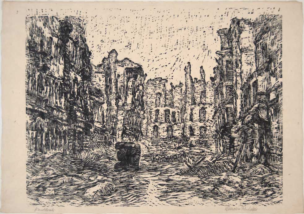
Wilhelm Rudolph, Frauenkirche in Dresden, o.J., Lithografie 37,8 x 39,9 cm, Kunstfonds, © SKD, Foto: Sabine Ulbrich.

Wilhelm Rudolph, Zöllner Straße, undatiert (nach 1945), Holzschnitt, Handruck, 53,5 x 76,2 cm, Kunstfonds © SKD, Foto: Stefanie Recsko.

Georg Christian Fritzsche Aufzug der Wagen und Reiter zum Damenfest am 6. Juni 1709, Amphitheater von M. D. Pöppelmann und Johann Friedrich Karcher, Kupferstichkabinett.

Stadtarchiv Dresden:

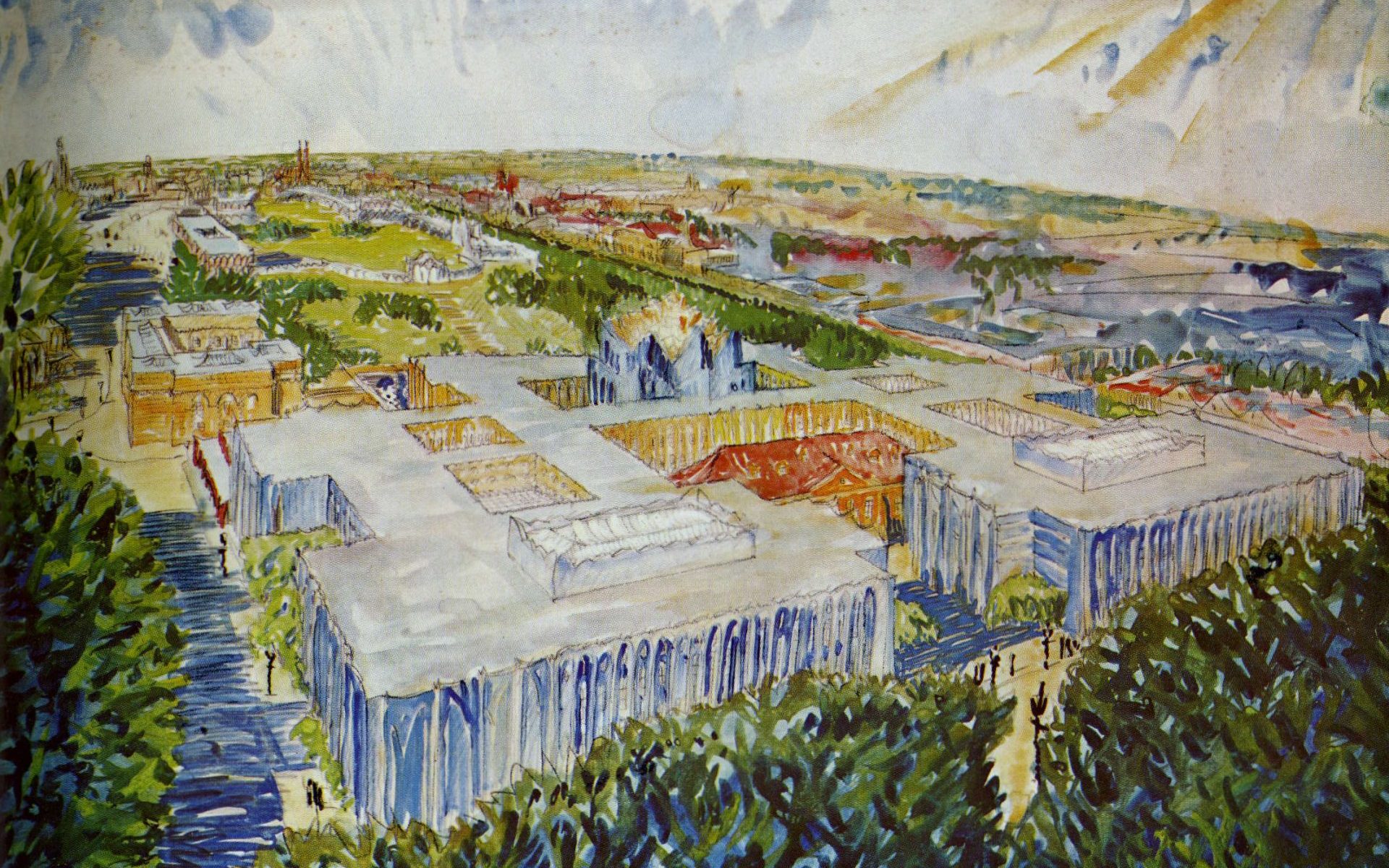
Herbert Schneider, Vorschlag für den Wiederaufbau von Dresden, 1946, Stadtarchiv Dresden, 6.4.40.1 Stadtplanungsamt Bildstelle, Nr. XIII5156, Fotograf/in unbekannt.

Fritz Müller, Neues Dresden, Entwurf 1946, Landeshauptstadt Dresden, Stadtplanungsamt, Schlüssel XIII5070.

Hanns Hopp, Neues Dresden, 1946, Perspektive der Stadtmitte vom Hauptbahnhof zum Altmarkt (G. Wiesemann in ihrer Monographie zu Hanns Hopp [2000]”).

Mart Stam, Aufbauplan, 1946, Landeshauptstadt Dresden, Stadtplanungsamt, Schlüssel XIII4018.

Prager Straße vom Newa ausgesehen, 1970, 6.4.40.1 Stadtplanungsamt Bildstelle, Nr. I6869, Fotograf·in unbekannt.

Stadtmuseum Dresden: 

Oswald Enterlein, Entwurf für ein Kulturhaus am Altmarkt, 1954, SMD/SD/2021/00203.

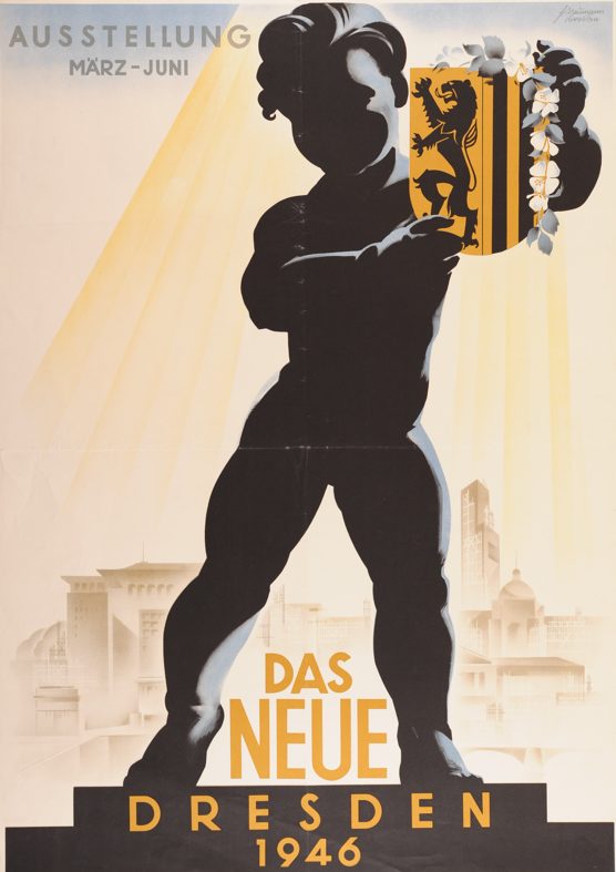
Horst Naumann, Plakat Das neue Dresden. Ausstellung vom Marz – Juni 1946 in der Stadthalle am Nordplatz, SMD/SP/1985/01050.

Andere / Privatsammlungen (Deutschland):

Klaus Willem Sitzmann, Photographie Frauenkirche & Neumarkt.

Birgit Schuh, Schokofluss, Dresden, 2011.

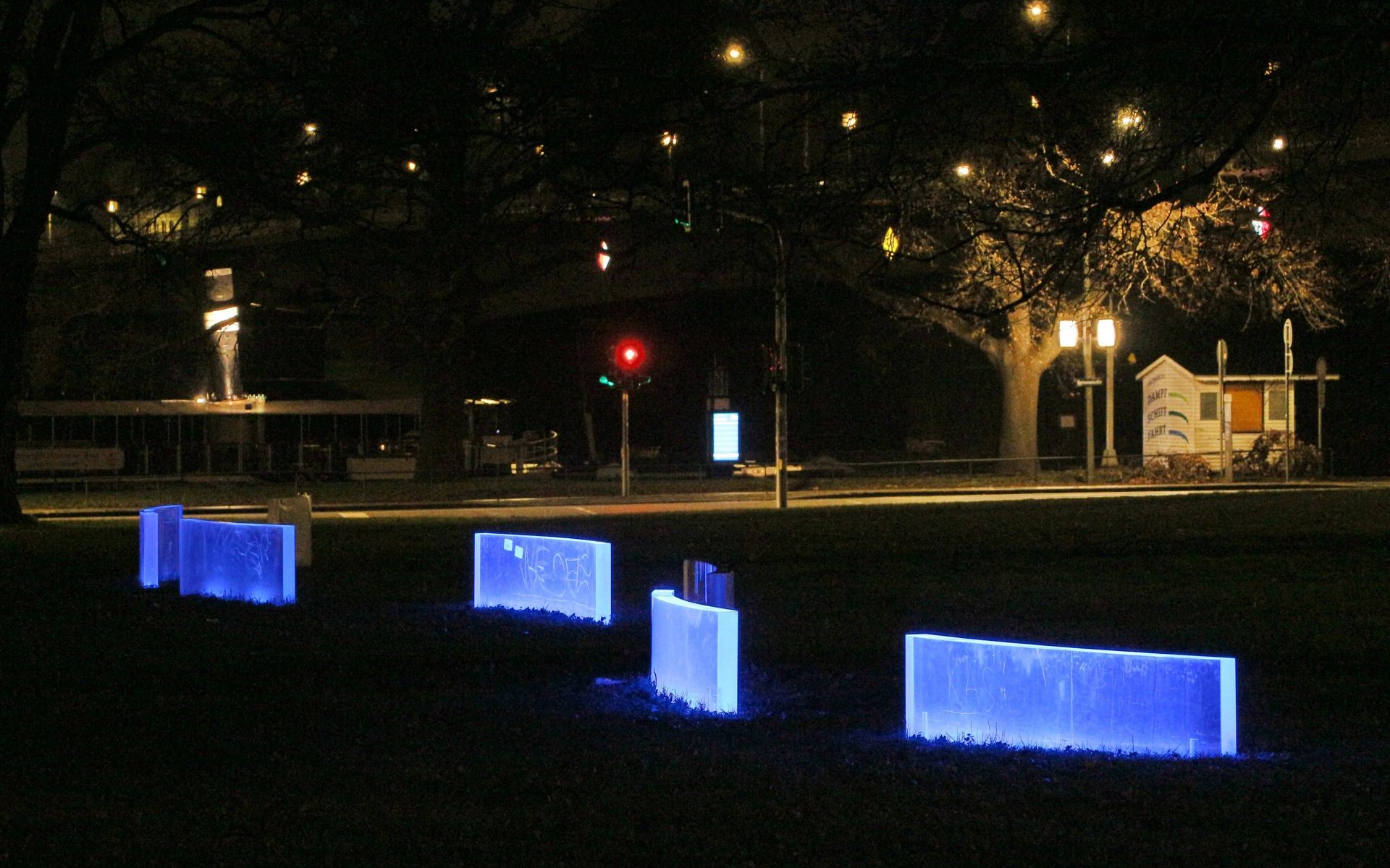
Kirsten Kaiser, Mnemosyne, Wasserkunstwerk der Dresdner Sezession 89 e.V., Dresden, 1993-2000.

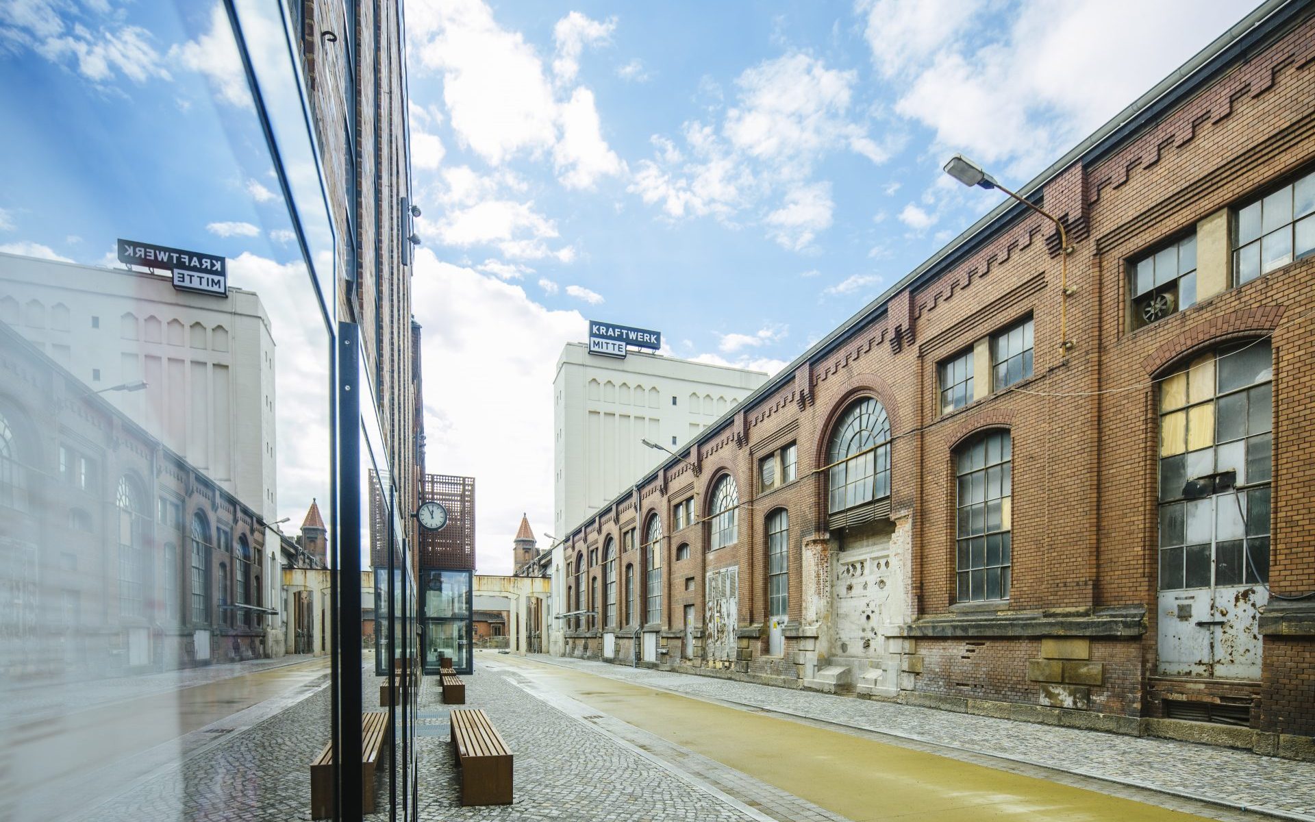
Kraftwerk Dresden Mitte, Fotograf: Oliver Killig¨.

Nils Schinker, Stadtentwicklung Dresdens 1919 bis 1933 (in Rot die neuen Gebäude aus den 1920er und 1930er Jahren.

Wikipedia:

Dresden-Äußere Neustadt, Böhmische Straße, August 1993.

Bunte Republik Neustadt Dresden.

Universitè de Bretagne Occidentale

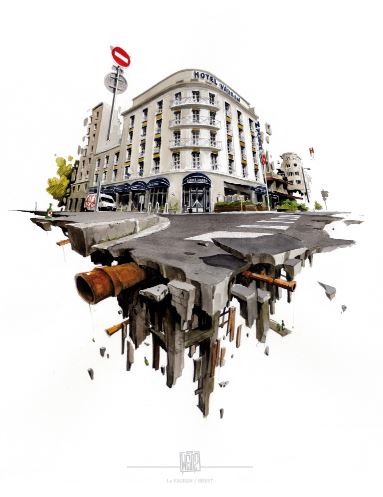
Ivana Radovanovic, Converging Visions, 2023.

Reinventing the town of Brest

This exhibition presents the work carried out by students as part of a university exchange
programme between the Institute of Geoarchitecture from the University of Western Brittany in Brest, the Faculty of Architecture from the Technical University of Dresden and the Faculty of Architecture from the University of Technology in Brno. The thinking undertaken helped to initiate the transdisciplinary project Res Urbanae on the theme of cities under reconstruction.

The exhibition opened in January 2023 in the Maison des Projets in Brest.

Students from the three universities visited Brest and Dresden in order to measure the architectural and urban planning challenges facing these cities. The poster boards and 3D models on display provide a comparative history of Brest and Dresden over time, highlighting similarities in their histories and their architectural and urban development. They also illustrate possible redevelopment projects for the former Pontaniou prison, situated in the Recouvrance district of Brest, in resonance with the Carré des Arts (the building which houses Brest’s Art school). The reconfiguration of the courtyards in the rebuilt city centre raises questions about the possibilities for urban renewal in the heart of Brest’s conurbation.


This work, which is exploratory in nature, responds to the initiatives put into place by the
municipality of Brest and its urban agglomeration. These studies reveal the extent of Brest’s
development potential in its ongoing reconstruction process.

Exhibition at the Maison des Projets. You can see posters and models of Brest.
Exhibition at the Maison des Projets
Posters of the students of the VUT in Brno about the former Pontainou prison
Posters of the students of the VUT in Brno about the former Pontaniou prison


Model of Brest 2022